Section Branding
Header Content
First Hurricane of the 2011 Season
Primary Content

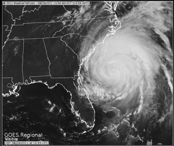
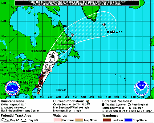
The first hurricane of the season was named over the weekend! Hurricane Irene formed on Saturday, August 20th at 7pm Eastern Daylight Time, about 190 miles east of Dominica. As of 11 am Friday, Hurricane Irene is exhibiting maximum sustained winds of 90 knots (105 mph), which makes Irene a Category 2 hurricane on the Saffir-Simpson scale. She also has a minimum central pressure of 946 millibars (27.93 inches of mercury), and she is moving towards the north at 12 knots (14 mph).
U.S. Air Force Hurricane Hunters have flown through Irene, and their observations indicate that Irene while Irene has decreased in strength, she has significant organization and a powerful structure. She will be a highly destructive hurricane when she makes landfall!
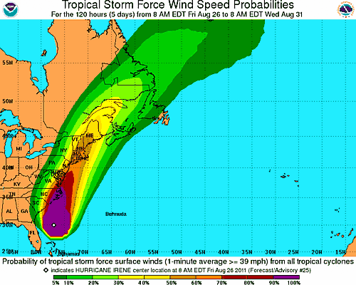
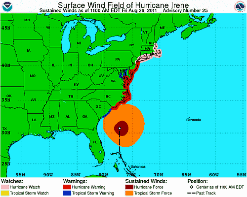
The National Hurricane Service's official forecast track suggests that Hurricane Irene will make a direct hit to North Carolina and later impact the New England states. Nevertheless, it is important to note that the landfalling forecast error on days 4 and 5 is 250 miles; this means that the center of the hurricane can strike land up to 250 miles from the forecasted "black" line in the NHC's graph. It is also important to note that Hurricane Irene is huge - the distance from the center to the outer rain bands is close to 250 miles. With that in mind, it is important to begin planning now for any action that needs to be taken, especially since the impacts from a hurricane can still be felt hundreds of miles from the storm's center. Although it looks like Georgia will avoid a direct hit from Irene, high surf and rip current advisories have been posted for coastal regions of Georgia, including coastal Camden and Glynn counties. Irene is a particularly large storm: hurricane force winds have been observed up to 90 miles from the center, and tropical storm winds have been observed up to 290 miles away from the center! A NOAA Buoy located about 40 miles south-southeast of Southport, North Carolina, recently measured wind gusts of 47 mph.
Hurricane Irene is a great example as to why it's important to plan for emergency situations. Before a tropical weather situation, discuss with your family the route and travel preparations you may need to take in the event of an evacuation. If you live further inland, don't assume that you are "immune" from tropical storms and hurricanes. Inland flooding is the number one weather killer in the United States, and tropical cyclones produce significant inland flooding when they come through the interior states. Prepare emergency action plans in case you experience flooding, and be sure to have flashlights, fresh batteries, fresh bottled water, and non-perishable food in your emergency kits.
I will continue to post updates regarding Hurricane Irene, but the best source for information is the National Hurricane Center's website. I would love to hear your feedback, and how you are preparing for Hurricane Irene!
On a side note, my meteorologist colleagues are noting the similarities between Irene and some historical storms, notably the "Long Island Express" storm from 1938, Hurricane Gloria from 1985, and Hurricane Bob from 1991. Gloria caused $1.84 billion (in 2011 dollars) in damage throughout the mid-Atlantic and New England States. Bob caused $2.42 billion (in 2011 dollars), and he was the most recent hurricane to strike the New England states.
Stay safe, and happy storm spotting!
Related Posts You May Like
Tour Through The Hurricane Hunters' Airplane!
A Hurricane By Any Other Name Would Still Be As Stormy
If A Storm Brews In The Tropics, Is It Really A Tropical Storm?
Secondary Content
Bottom Content


