Section Branding
Header Content
Winter Storm Headed Toward The State Will Hit Middle Georgia The Hardest
Primary Content
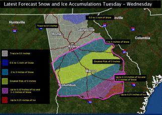
A winter storm watch has been issued for most of Georgia from Rome to Gainesville south.
Meteorologist George Wetzel with the National Weather Service says wet weather from the Gulf will meet up with arctic air coming down from the north starting Tuesday and running into Wednesday morning.
He says an oval running across the state in middle Georgia will see the most snow.
“That is going to be north of a line from LaGrange to Macon, to the east of there toward Dublin, and south of the Atlanta metro. So that’s about 3 to 4 inches there.”
In southern Georgia, the oval will start as sleet and freezing rain, and the coast will also see sleet and flurries.
From Atlanta north, there could be 1 to 2 inches of snow. From Atlanta down to Macon, LaGrange and Dublin they could see 3 to 4 inches of snow. The rest of the state could see a dusting of snow along with sleet and freezing rain.
Wetzel says driving may be treacherous across Georgia for Tuesday’s rush hour and Wednesday morning
The whole state will face icy roads. Southern Georgia and the coast could see light snow ,sleet and freezing rain, while middle and northern Georgia could see 1 to 4 inches of snow.
Wetzel says the roads will get better later in the week when the weather warms up.
“On Thursday and Friday, temperatures on Thursday into the upper 30’s and 40’s and temperatures on Friday into the lower 50’s, so this will not stick around long."
Tags: weather, middle Georgia, winter storm
Bottom Content