
Section Branding
Header Content
Warmest March On Record
Primary Content

It’s half-way into April, but the air temperatures are 10 to 15 degrees cooler than they were last month!!! Check out the readings from throughout the state during one of the warmest spring months on record.

Data courtesy of the NWS Weather Forecast Office in Peachtree City, Georgia.

Data courtesy of the NWS Weather Forecast Office in Jacksonville, Florida.
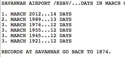
Data courtesy of the NWS Weather Forecast Office in Charleston, South Carolina.
So what caused this early heat wave and influenced our abnormally mild winter in the first place?
Three main ocean/atmospheric patterns set up this year to keep us predominantly warm and dry. These patterns are called “teleconnections” because their presence can affect the weather far away, in a different part of the globe.
The first teleconnection of note this winter is the La Nina. While many people have heard of El Nino, La Nina is a similar yet different pattern (El Nino and La Nina are collectively called the El Nino Southern Oscillation, or ENSO for short). According to the National Oceanic and Atmospheric Administration, “La Niña is associated with cooler than normal water temperatures in the Equatorial Pacific Ocean, unlike El Niño which is associated with warmer than normal water” (Source: NOAA). La Ninas affect the southeastern United States by deflecting most storm tracks to the north, keeping the southeast warm and dry.
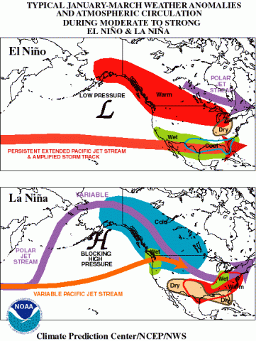
Image courtesy of the Climate Prediction Center.

Data courtesy of the Climate Prediction Center.
La Nina conditions have been observed since mid-2010. However, this winter has been considerably warm, and winter 2011 was extremely cold despite the La Nina conditions. There are other teleconnections that also affect the weather, including the Arctic Oscillation and the North Atlantic Oscillation.
According to NASA’s Earth Observatory, “The AO is a pattern of differences in air pressure between the Arctic and mid-latitudes. When the AO is in “positive” phase, air pressure over the Arctic is low, pressure over the mid-latitudes is high, and prevailing winds confine extremely cold air to the Arctic. But when the AO is in “negative” phase, the pressure gradient weakens. The air pressure over the Arctic is not quite so low, and air pressure at mid-latitudes is not as high. In this negative phase, the AO enables Arctic air to slide south and warm air to slip north” (Source: NASA Earth Observatory).
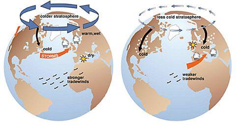
Image courtesy of J. Wallace, University of Washington, and the National Snow and Ice Data Center.
For the majority of the 2012 winter, and especially during the month of March, the Arctic Oscillation exhibited positive phase conditions. However, during the 2010 and 2011 winters, the Arctic Oscillation exhibited negative phase conditions.
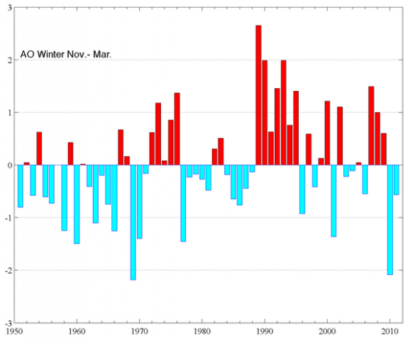
Data courtesy of NOAA's Arctic Change Indicator Website.

Data courtesy of the Climate Prediction Center.
Similar to the Arctic Oscillation is the North Atlantic Oscillation (NAO). According to the State Climate Office of North Carolina, “The North Atlantic Oscillation (NAO) consists of two pressure centers in the North Atlantic: one is an area of low pressure typically located near Iceland, and the other an area of high pressure over the Azores (an island chain located in the eastern Atlantic Ocean)… the AO and NAO are two separate indices that are ultimately describing the same phenomenon of varying pressure gradients in the northern latitudes and the resultant effects on temperature and storm tracks across the continent.” (Source: State Climate Office of North Carolina). Positive phases of the NAO correspond to above average temperatures in the eastern United States, while negative phases of the NAO correlate to below average temperatures over the eastern United States. For the majority of winter 2011-2012, the NAO has been in a positive phase.
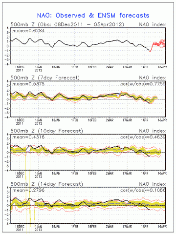
Data courtesy of the Climate Prediction Center.
There are other teleconnections that can impact the weather over a span of weeks to months, including the Pacific North American (PNA) oscillation and the Madden-Julian Oscillation (MJO). For the most part, though, La Nina and the AO/NAO came together to produce a pleasantly mild winter for 2011-2012.
For you weather/science buffs, I found a great blog that goes into these teleconnections more thoroughly: Doctoochweather.wordpress.com. You can also the follow the data along with the Climate Prediction Center at www.cpc.ncep.noaa.gov.
We’ve experienced a mild winter and a warm spring, so what is on the horizon for summer? Stay tuned for an upcoming blog post detailing the possibilities for this summer’s weather. In the meantime, happy storm spotting!
Lans Rothfusz, the Meteorologist In Charge at the National Weather Service in Peachtree City, explains winter climatology.
Additional Resources You May Like
"Record Temperatures Melt Away, Giving Meteorologists 'Uneasy Feeling'"(Statesman.com News Article)
"Warm Winter Speeds Road Projects"(GPB News Article)
DocToochWeather Blog
Climate Prediction Center
NASA's Earth Observatory


