Section Branding
Header Content
Hurricane Sally Drops 'Incredible Rainfall Totals' On Alabama And Florida
Primary Content
Updated at 1:30 p.m. ET
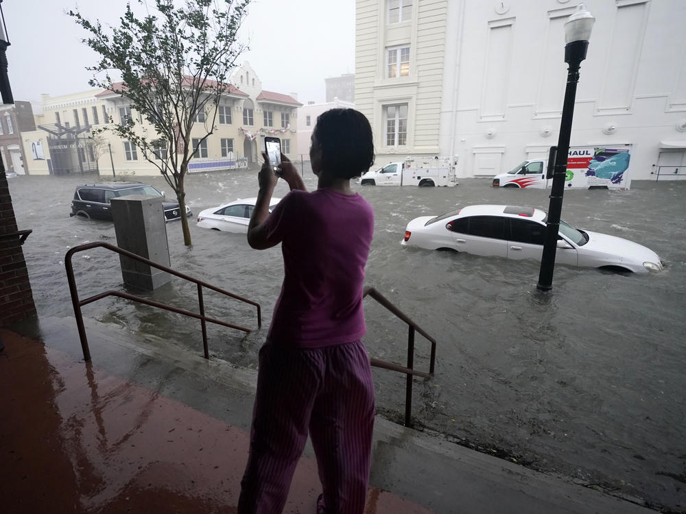
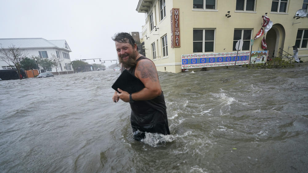
Hurricane Sally brought 100 mph winds and the threat of historic flooding to southeastern Alabama and the western Florida Panhandle on Wednesday morning, after making landfall as a Category 2 storm. Some isolated areas in its path could see nearly 3 feet of rain.
"Winds have ripped at buildings and rising floodwaters forced people to their rooftops for rescue," NPR's Debbie Elliott reports from Gulf Shores, Ala. "The slow-moving storm dumped torrential rainfall ahead of landfall, and a storm surge more than 5 feet sent waves washing through homes in Orange Beach."
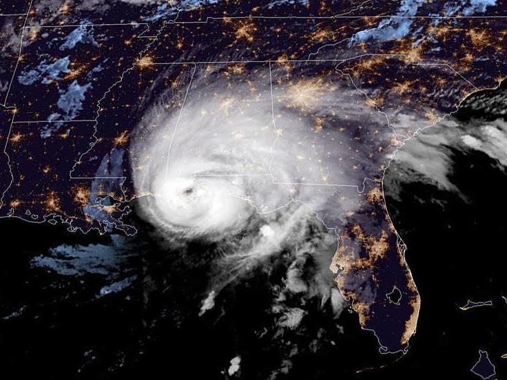
The hurricane made landfall near Gulf Shores, just west of the Florida border, around 5:45 a.m. ET, the hurricane center said. Thanks in large part to its slow motion, the storm will bring "catastrophic and life-threatening flooding" to parts of the north-central Gulf Coast, the agency says.
"We've seen some incredible rainfall totals — measured in feet," NHC Director Ken Graham said in an online briefing late Wednesday morning. "And we still have some more rain to come."
Sally is moving at 5 mph — slightly faster than the 2 to 3 mph recorded as the storm crept ashore. Its sustained winds have fallen to 75 mph, and its center is about 20 miles north of Pensacola, Fla., moving north-northeast, the National Hurricane Center said in its 1 p.m. ET update.
The storm has left thousands of people without power. More than 230,000 electricity customers were without power in Alabama on Wednesday morning — more than 10% of all accounts in the state, according to the tracking site PowerOutage.us. Roughly 200,000 accounts in Florida were also out, the site said.
At 6 a.m. ET, Dauphin Island, Ala., was reporting sustained winds of 81 mph and gusts up to 99 mph. In Florida, the Pensacola Naval Air Station reported 61 mph winds, with gusts up to 86 mph.
On Dauphin Island, charter boat captain Charlie Gray, a longtime resident of Alabama's coast, described Sally's landfall to member station WBHM's Miranda Fulmore:
"All you could hear was rumbling, things crashing and breaking and twisting. You hear metal banging, and wrapping around the palm trees where it's like you took a piece of aluminum foil and wrapped it around your finger."
In Gulf Shores, the damage from Sally is "EXTENSIVE," the National Weather Service says.
"The Gulf State Park Pier was cut in half," the agency adds, posting an image of the partially destroyed structure that had just undergone a multi-million-dollar renovation in Gulf Shores. The repairs included extensive use of the Brazilian hardwood ipe — a very dense and strong material. The pier had been poised to reopen in mid-September, after months of delays.
Long before Sally made landfall, it had soaked and flooded parts of the Gulf Coast, as it meandered along and dithered, heading first northwest and then north before curling north-northeast. Now, it's bringing the full force of its winds and rains to coastal areas like Pensacola.
The storm's disastrous effects are expected to include "considerable roof damage to sturdy buildings" and large trees snapped off at their base, the local National Weather Service office says. It warns of "damage accentuated by airborne projectiles. Locations may be uninhabitable for weeks."
A section of the Three Mile Bridge collapsed over Pensacola Bay, according to Santa Rosa County's emergency agency. The bridge was closed on Tuesday, when it was also struck by a barge.
In Baldwin County, which includes Gulf Shores, the Magnolia River will exceed its flood stage record, county emergency management director Zach Hood said.
"That's not the only river that will reach historical, astronomical flood stage," Hood warned, saying that Sally will continue to affect the area. He urged people to shelter in place — preferably on high ground.
"This is widespread," Hood added. "Yes, our coast has taken a very devastating hit. But throughout the entire county, we are seeing reports of major debris, we're seeing power lines [downed], we're seeing very dangerous conditions in terms of the weather. These will continue."
The rain could quickly overwhelm drainage infrastructure: Sally is expected to drop 8 to 12 inches through Wednesday afternoon, with overall storm totals of 10 to 20 inches and isolated amounts of 35 inches. The massive amount of water will trigger "moderate to major river flooding," the hurricane center says.
"This will be a long duration event," the National Weather Service office in Mobile, Ala., said on Facebook. "Folks along the coast need to continue to hunker down and shelter this morning."
To that, the most-liked reply came from a reader who said simply, "It can hurry up" — a sentiment shared by many along the Gulf Coast.
The threat of mass flooding prompted Alabama Gov. Kay Ivey to urge residents and tourists along the coast to evacuate earlier this week.
In Florida, Escambia County, which includes Pensacola, is under voluntary evacuation orders, as are several neighboring counties — a list that grew as Sally took a sharper turn toward the east, and away from Louisiana and Mississippi.
While the hurricane's rain and storm surge are expected to pose the most perilous threat to people and property, Sally's winds intensified in the last 12 hours before landfall, from 80 mph at 7 p.m. on Tuesday to 105 mph at landfall.
Sally is extending hurricane-force winds outward up to 40 miles from its center, and tropical-storm-force winds for 125 miles.
The hurricane's storm surge could bring from 4 to 7 feet of water in the worst-hit areas. A storm surge warning is in effect from Dauphin Island to the Walton/Bay County line in Florida.
The storm could also spin off tornadoes as it makes its way across the Florida Panhandle, southern Alabama and southwestern Georgia.
Sally is expected to maintain a northeast direction and to increase its forward motion a bit Wednesday night and into Thursday. But it will still linger over the Southeast, raising the threat of floods through parts of Georgia, South Carolina, North Carolina and Virginia.
"The center of Sally will move across the extreme western Florida panhandle and southeastern Alabama through early Thursday, and move over central Georgia Thursday afternoon through Thursday night," the hurricane center says.
Copyright 2020 NPR. To see more, visit https://www.npr.org.


