Section Branding
Header Content
Tropical Storm Tammy expected to drop heavy rain on the Caribbean this weekend
Primary Content
Updated October 19, 2023 at 11:38 AM ET
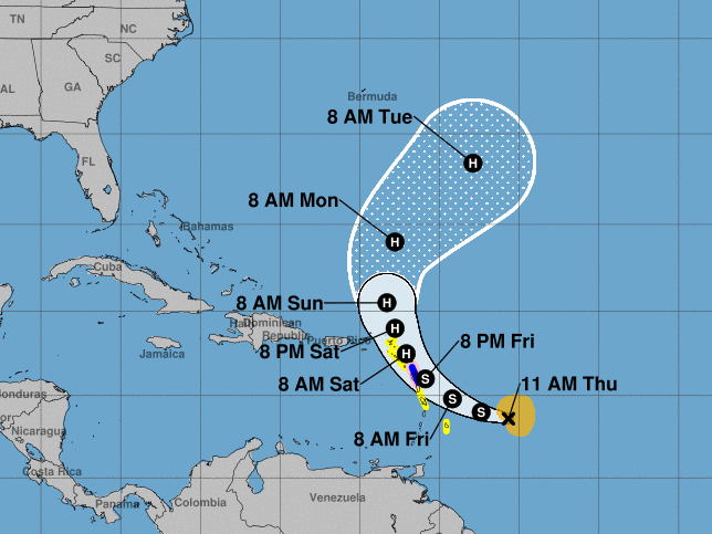
A tropical storm that's churning in the North Atlantic ocean is expected to begin moving West, strengthening as it makes landfall across a string of Caribbean islands in the coming days.
Forecasters say the storm system, which is being called Tammy, could gradually strengthen into a hurricane in the next 48 hours, bringing heavy rain and storm surge to the region.
Here's a look at what we know.
When and where is Tammy forecast to make landfall?
The storm currently has sustained winds of 60 mph and is moving quickly to the west towards the Lesser Antilles, according to a Thursday morning advisory from the National Hurricane Center (NHC).
Tammy is forecast to rake across many of the smaller island countries in the eastern Caribbean, with the center of the storm passing over the Leeward Islands on Friday and Saturday. Rainfall of up to 10 inches could produce flash flooding and mudslides. Storm surge could raise water levels by as much as 3 feet.
Tropical storm watches are in effect for Barbados, Dominica, Martinique, Guadeloupe, Antigua, Barbuda, Montserrat, St. Kitts, Nevis, Anguilla, St. Barthelemy, St. Martin, Saba and St. Eustatius. Meteorologists say additional watches or warnings will likely be required on Thursday and Friday.
Heavy rainfall of up to 4 inches is also expected to spread across the U.S. and British Virgin Islands and Puerto Rico by this weekend. By Monday, the storm is expected to swing out to sea and no longer be a threat.
How does Tammy compare to other storms we've seen this season?
So far this year, the NHC has tracked 18 hurricanes and tropical storms, according to the last updated count, released Oct. 1. Only about a third of those made landfall, including Idalia, which left homes and businesses underwater as it battered the Florida coast.
This year's early storm activity prompted forecasters to update their 2023 season outlook, changing their "near-normal" projection made in May to "above-normal" in August. The National Oceanic and Atmospheric Administration predicted 14 to 21 storms, with about half of those being full-blown hurricanes.
The main reason scientists expected higher levels of hurricane activity is that ocean water in areas of the Atlantic Ocean is abnormally warm this year, part of a global trend of rising ocean temperatures.
Federal officials have warned people who live in hurricane-prone regions not to focus on the overall number of storms, as just one storm can cause significant damage.
Some of the island nations in Tammy's paths are still recovering from Hurricane Maria, a category 5 storm that nearly wiped out places like Dominica when it made landfall six years ago.
What's happening with Hurricane Norma?
Forecasters are tracking a second storm system, Hurricane Norma, as it travels towards Baja California, Mexico. A hurricane watch is in effect for the peninsula, stretching from Todos Santos to Los Barriles.
The category 3 storm is expected to weaken as it approaches land on Saturday, but could still bring rainfall totaling 15 inches over the weekend.
NPR's Russell Lewis contributed reporting.
Copyright 2023 NPR. To see more, visit https://www.npr.org.

