Section Branding
Header Content
Hurricane Beryl makes landfall with 150 mph winds on Caribbean island
Primary Content
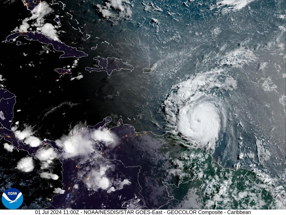
The eye of Hurricane Beryl "made landfall on Carriacou Island" at 11:10 a.m. ET, bringing 150 mph winds and a dangerous storm surge to islands on the eastern edge of the Caribbean, the National Hurricane Center said. The storm hit the island after another round of rapid strengthening.
"This is an extremely dangerous and life-threatening situation. Take action now to protect your life!" the center said ahead of Monday's landfall. "Residents in the Grenadine Islands and Carriacou Island should not leave their shelter as winds will rapidly increase within the eyewall of Beryl."
The Category 4 storm has been moving at 20 mph. Its center passed well south of Barbados, but Beryl still hammered the island with winds that gusted up to 70 mph.
As of 2 p.m. ET, the government of Barbados has discontinued its hurricane warning for the island.
Warnings remain in place for St. Vincent, the Grenadine Islands and Grenada. A less urgent hurricane watch — meaning hurricane conditions are possible, though not explicitly expected — is in place for Jamaica.
Beryl has put up some eyepopping numbers in recent days, with warm ocean water allowing it to quickly gain strength after becoming a tropical depression on Friday. When it blossomed into a Category 4 storm on Sunday, it became the first Atlantic hurricane on record to attain that status in June.
How dangerous is the storm?
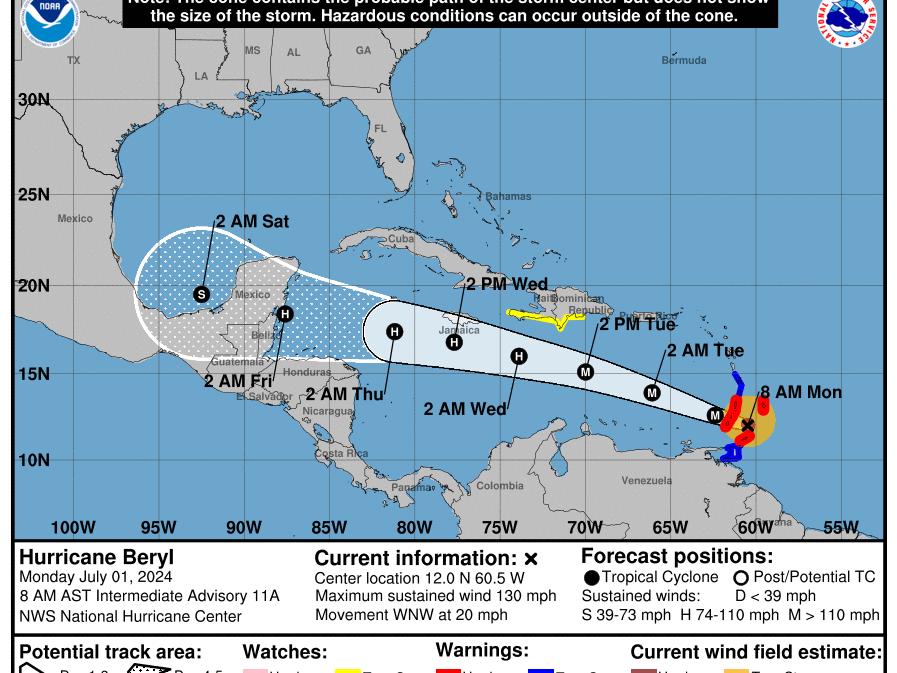
Beryl weakened slightly to a Category 3 storm early Monday, but meteorologists predicted it would likely gain power again after an eyewall replacement took place in that same timeframe.
Its sustained winds of 140 mph place Beryl's in Category 4 on the Saffir-Sampson wind scale. The power of storms in that class is fierce.
"There is a very high risk of injury or death to people, livestock, and pets due to flying and falling debris," according to the NHC. "Nearly all older (pre-1994) manufactured homes will be destroyed. A high percentage of newer manufactured homes also will be destroyed," and poorly built homes could see all of their walls collapse.
While hurricane winds draw much attention, the cyclones pose the greatest threat to life with floodwater, from rain and storm surge.
"A life-threatening storm surge will raise water levels by as much as 6 to 9 feet above normal tide levels" close to its landfall, the NHC said.
Beryl is forecast to drop 3 to 6 inches of rain across the Windward Islands through Monday afternoon.
Despite passing south of Barbados, Barbados Meteorological Services Director Sabu Best said in an update early Monday that wind gusts were dangerously strong, from 50 up to 70 mph, urging residents to stay inside until an "all clear" has been announced. Rainfall, he added, had not been as bad as expected.
What is Beryl's expected path?
The hurricane is currently heading west-northwest, moving through the Windward Islands Monday morning before heading across the southeastern and central Caribbean Sea, the NHC said.
A west-northwest track is a common heading for an Atlantic hurricane. And while many storms that have hit the U.S. have eventually curved distinctly toward the north, Beryl is currently forecast to maintain a predominantly westward motion until it hits Mexico. Its current forecast track is further south than earlier predictions.
On its current forecast path, the earliest tropical storm-force winds are expected to hit Central America Wednesday night. Mexico's coastal states of Quintana Roos and Yucatan will likely feel those winds on Thursday.
What about the warming ocean?
Climate change — and specifically, an established trend of warmer ocean and air temperatures — has led to more intense hurricanes and other storms. And this year, that dynamic is already rewriting the record books.
Since forming in late June, Beryl is now the earliest Category 4 Atlantic storm; it was also "the farthest east that a hurricane has formed in the tropical Atlantic (=23.5°N) in June on record, breaking the old record set in 1933," as Colorado State University meteorologist Phil Klotzbach said on X.
Near-record warm ocean temperatures in the Atlantic were cited as one reason National Weather Service forecasters have predicted an unusually active Atlantic hurricane season, with up to 25 named storms.
Warm ocean water contributes to a storm’s explosive growth — as was the case in 2021, when 84-degree waters drove Hurricane Sam to become a major storm in a similar part of the Atlantic as Beryl. But that was in September, not June.
Bottom Content
