Section Branding
Header Content
UPDATES: Hurricane Debby impacts Georgia. Here's what you need to know
Hero Image
Primary Content
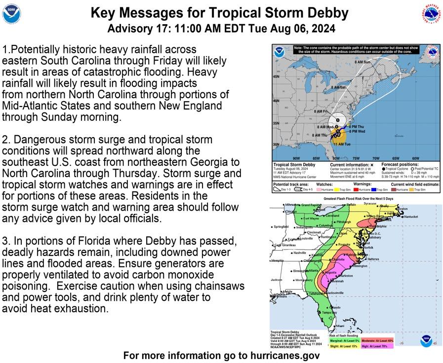
Hurricane Debby will bring tropical wins and potentially historic rainfall amounts and areas of catastrophic flooding to Georgia, with conditions beginning Monday, Aug. 5 and impacts lasting through the middle of the week or as late as Thursday, Aug. 8, 2024, the National Weather Service and the National Oceanic and Atmospheric Association hurricane prediction center reported Sunday. The highest rainfall totals will occur across Coastal Georgia and South Carolina, including the Savannah and Charleston metropolitan areas. Tropical storm force winds are possible across South Georgia, which could lead to downed trees and power lines.
For current watches and warnings from the National Weather Service, click here.
For local emergency management information in Coastal Georgia, click on the county name: Chatham, Bryan, Liberty, McIntosh, Glynn, and Camden. For all other counties, visit GEMA.
Here's Red Cross information on Georgia shelters and assistance.
If you lose power and are a Georgia Power customer, you can check this power outage map. With an EMC? Start here or here.
The Federal Emergency Management Agency (FEMA) informs the public and provides disaster claims and assistance during the storm.
This is a potentially significant and life-threatening event. Please listen to local authorities for any evacuation orders or recommendations and follow this blog or GPB.org/Storms for impact updates.
____
Wednesday, Aug. 7 at 7:30 a.m.
The Tropical Storm warning for Coastal Georgia ended last night. This expired warning included county regions Coastal Bryan, Coastal Chatham, Coastal Liberty, Coastal McIntosh, Effingham, Hampton, Inland Bryan, Inland Chatham, Inland Liberty, and Inland McIntosh.
Savannah will see scattered showers and storms through Thursday but less rain than predicted.
A Flood Watch remains in effect for Southeast Georgia through Friday morning, mainly for rivers, creeks and low-lying areas.
__
Tuesday, Aug. 6 at 5 p.m.
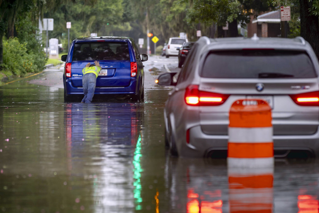
GPB's Benjamin Payne in Savannah reports the Savannah Fire Department conducted 18 water rescues on Monday, according to the city. No injuries or deaths were reported.
Schools in the Savannah-Chatham County Public School System were closed Tuesday and will remain closed Wednesday.
__
Tuesday, Aug. 6 at 1 p.m.
GPB's Benjamin Payne in Savannah reports the rain from Tropical Storm Debby has been lighter than what was initially forecast by the National Weather Service.
Eight inches of rain was recorded over the past 24 hours at the U.S. Army Corps of Engineers' downtown gauge along the Savannah River.
The National Weather Service is forecasting another 5.5 inches through Friday. Taken together, 13.5 inches by week's end would be about two-thirds of the agency's original forecast of 20 inches.
____
Tuesday, Aug. 6 at 11:15 a.m.
More shelters are available to Georgia residents affected by the storm in Effingham County and the Savannah area.
The updated list of open shelters now includes the following:
- Springfield Oaks Church - Springfield, Ga. (Effingham County)
- Savannah Civic Center - Savannah, Ga. (Chatham County)
- Enmarket Arena - Savannah, Ga. (Chatham County)
- Tompkins Regional Center - Savannah, Ga. (Chatham County)
- Central Square Complex - Douglas, Ga. (Coffee County)
- Park Avenue United Methodist Church - Valdosta, Ga. (Lowndes County)
- Selden Park - Brunswick, Ga. (Glynn County)
- PSA Recreation Center - Kingsland, Ga. (Camden County)
For the map, click here.
NHC Update
NHC updates that Georgia can expect tropical storm conditions to travel from northeastern Georgia to North Carolina through Thursday, August 8, 2024.
____
Tuesday, Aug. 6 at 10:15 a.m.
American Red Cross’ interactive map shows another shelter opened in Coffee County for families and individuals forced to evacuate their homes.
The open shelters are now:
- Central Square Complex - Douglas, Ga. (Coffee County)
- Park Avenue United Methodist Church - Valdosta, Ga. (Lowndes County)
- Selden Park - Brunswick, Ga. (Glynn County)
- PSA Recreation Center - Kingsland, Ga. (Camden County)
For the map, click here.
____
Tuesday, Aug. 6 at 8:30 a.m.
Thousands of Georgians remain without power as Tropical Storm Debby continues to move throughout Georgia's coast.
NPR reported that, as of 5 a.m. Tuesday, the storm was 50 miles southwest of Savannah, with maximum winds of 45 miles per hour.
Storm surge and tropical storm advisories are in effect for Coastal Georgia.
Tune into GPB.org at 9:15 a.m. to watch the live briefing from GEMA about Tropical Storm Debby.
____
Monday, Aug. 5 at 4:30 p.m.
Thousands of Georgians are without power as Tropical storm Debby continues to move throughout Georgia's coast.
In an recent update Georgia EMC reports that there are 40,877 outages throughout the state.
There are outages in the following regions:
- Southwest Georgia - 2,161 outages
- South Georgia - 35,466 outages
- Southeast Georgia - 2,600 outages
____
Monday, Aug. 5 at 3 p.m.
GPB's Benjamin Payne in Savannah updates that Savannah residents who live in flood-prone areas can park for free in any of the six city-owned parking garages downtown starting at 5 p.m. Monday.
Trailers, boats and other vehicle attachments are not allowed.
Chatham Area Transit will suspend bus service no later than 6 p.m. Paratransit service and the Savannah Belles Ferry will end operations at noon Tuesday.
____
Monday, Aug. 5 at noon
The American Red Cross’ interactive map for open shelters now shows three Georgia shelters open for families and individuals forced to evacuate their homes.
The open shelters in Georgia so far are:
- Park Avenue United Methodist Church - Valdosta, Ga. (Lowndes County)
- Selden Park - Brunswick, Ga. (Glynn County)
- PSA Recreation Center - Kingsland, Ga. (Camden County)
For the map, click here.
____
Monday, Aug. 5 at 11 a.m.
The National Hurricane Center provided an update with the latest news on Tropical Storm Debby. NHC Director Michael Brennan revealed that the storm is currently 25 miles west of Lake City, Fla., in the northern part of Florida.
"We take a look at the radar," he said. "You can see the center of Debby here between Tallahassee and Lake City, but you can see that large expansive rain shield with heavy rainfall now falling across much of southeastern Georgia into Savannah moving now into Charleston. This rain shield is going to continue to expand northward and eastward through the next several days."
Brennan also said the region is expected to see a tornado threat develop throughout the day and continue from portions of Florida, Georgia, and South Carolina.
Savannah curfew
GPB's Benjamin Payne in Savannah reports Savannah Mayor Van Johnson said that he will issue a curfew effective 10 p.m. Monday through 6 a.m. Tuesday. Rainfall from Debby is forecast to be heaviest during this timeframe for the city, which is forecast to get as much as 20 inches of rain through the end of the week.
____
Monday, Aug. 5 at 10 a.m.
Gov. Brian Kemp issued an executive order allowing the Georgia Department of Defense to provide up to 2,000 National Guard troops to be used in preparation, response and recovery efforts associated with Tropical Depression 4 (now Hurricane Debby).
____
Monday, Aug. 5 at 9 a.m.
Gov. Brian Kemp declared a state of emergency for all 159 counties in Georgia Sunday afternoon. Hurricane Debby is expected to become a tropical storm as it very slowly moves along the Southeast coast through mid-to-late week, resulting in prolonged impacts to the region. A combination of freshwater flooding and storm surge will produce coastal inundation of 2 to 4 feet along the Southeast Georgia and Southeast South Carolina coasts, especially Tuesday through Thursday. Tropical storm force wind impacts and several tornadoes are also possible during this time, with highest chances across coastal areas.
Georgia Emergency Management and Homeland Security Agency (GEMA/HS) will continue to monitor the storm and is ready to assist local emergency management agencies should the need arise, said GEMA/HS Director Chris Stallings.
Potential impacts
Flooding rain:
- Prepare NOW to protect against life-threatening rainfall flooding having possible devastating impacts.
- Extreme rainfall flooding could prompt widespread rescues. As the event unfolds, rescues could become impossible.
- Rivers and tributaries could overwhelmingly overflow their banks in many places with deep moving water. Small streams, creeks, canals, and ditches may become raging rivers with strong currents. Flood control systems and barriers could become stressed or overwhelmed.
- Flood waters will enter many structures within multiple communities, some structures becoming uninhabitable or washed away.
- Flood waters could render escape routes impassable as streets and parking lots become rivers of raging water with underpasses submerged, making driving impossible and life threatening. Widespread road and bridge closures are possible, with most weakened or washed out.
- Drinking water and sewer services could be negatively impacted.
- Hazardous containers and materials could possibly be present in flood waters.
Storm surge:
- Areas of inundation of saltwater along immediate shorelines and in low-lying spots farther inland near rivers and creeks, with storm surge flooding accentuated by waves, could damage several buildings, mainly near the coast.
- Sections of near-shore escape routes and secondary roads could become weakened or washed out, especially in normally vulnerable low spots.
- Moderate to major beach erosion is possible with heavy surf breaching dunes. Strong and numerous rip currents are likely.
- Minor to moderate damage to marinas, docks, boardwalks and piers could occur. Several small craft may break away from moorings, especially in unprotected anchorages. Some navigation aids could become displaced well off station, creating difficult navigation near inlets and waterways.
- Elsewhere across southeastern South Carolina and Southeast Georgia, little to no impact is anticipated.
Wind:
- Some damage is possible to roofing and siding materials, along with damage to porches, awnings, carports, and sheds. A few buildings may experience window, door, and garage door failures. Mobile homes could be damaged, especially if unanchored. Unsecured lightweight objects can become dangerous projectiles.
- Several large trees could become snapped or uprooted, but with greater numbers in places where trees are shallow rooted.
- Some roads may become impassable from large debris, and more within urban or heavily wooded places. A few bridges and access routes could become impassable.
- Travel by vehicle or on foot becomes increasingly difficult in high winds. There's danger of death or injury from falling objects such as trees or electric wires outside.
- Scattered power and communications outages are possible — more prevalent in areas with above ground lines — which could persist for hours or days.
- Some poorly secured small craft could break loose from their moorings.
Tornadoes:
- Isolated to scattered tornadoes can hinder the execution of emergency plans.
- Scattered locations could experience enhanced damage due to tornadoes, including power loss and communications failures.
- Scattered locations could see roofs torn off frame houses, mobile homes demolished, boxcars overturned, large trees snapped or uprooted, vehicles tumbled and small boats tossed about.
Other coastal hazards:
- Significant beach erosion and a high risk for powerful and dangerous rip currents can be expected this week.
Evacuations:
Follow the advice of local officials.
Preparedness:
- Now is the time to complete all preparations to protect life and property in accordance with your emergency plan. Ensure you are in a safe location before the onset of strong winds or possible flooding.
- Rapidly rising flood waters are deadly. If you are in a flood-prone area, consider moving to higher ground. Never drive through a flooded roadway. Remember, turn around don`t drown!
- If heading to a community shelter, become familiar with the shelter rules before arrival, especially if you have special needs or have pets. Take essential items with you from your emergency supplies kit.
- Keep cellphones well charged. Cellphone chargers for automobiles can be helpful, but be aware of your risk for deadly carbon monoxide poisoning if your car is left idling in a garage or other poorly ventilated area.
- It is important to remain calm, informed, and focused during an emergency. Be patient and helpful with those you encounter.
- Closely monitor weather.gov, noaa weather radio or local news outlets for official storm information. Be ready to adapt to possible changes to the forecast. Ensure you have multiple ways to receive weather warnings.
- For information on appropriate preparations, see ready.gov
- For information on creating an emergency plan, see getagameplan.org
- For additional disaster preparedness information, see redcross.org
Sources: NOAA, GEMA
Secondary Content
Author

Bottom Content
