Section Branding
Header Content
Helene reaches hurricane strength with no signs of slowing as it approaches Florida
Primary Content
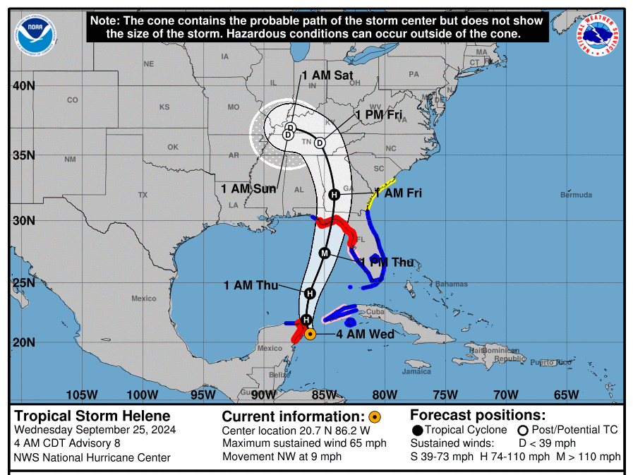
Helene has strengthened into a hurricane as it enters the Gulf of Mexico, forecasters said late Wednesday morning. They warn that it is poised to continue intensifying as it hurtles toward Florida, where it is expected to make landfall on Thursday.
The storm is expected to bring "life-threatening storm surge, damaging winds and flooding rains to a large portion of Florida and the southeastern United States, according to the National Hurricane Center (NHC).
"Preparations to protect life and property should be completed by early Thursday since tropical storm conditions are expected to begin within this area on Thursday,” it said.
Helene, which reached tropical storm status shortly after forming in the northwestern Caribbean Sea on Tuesday, is forecast to pass between the Yucatán Peninsula and the western part of Cuba on Wednesday.
As of 11 a.m. ET, its center was about 500 miles south-southwest of Tampa, Fla., and its maximum sustained winds were 80 mph, which makes it a Category 1 hurricane.
Forecasters warn that the storm, fueled by abnormally warm Gulf waters, will get even stronger before it reaches land. It could reach maximum sustained winds of 125 mph by late Thursday, which would make it a Category 3 hurricane, forecasters say.
"There is still some uncertainty on exactly how strong Helene will get, and upward adjustments to the forecast intensity could be required in subsequent advisories if Helene rapidly intensifies more than forecast," they said. "Regardless, Helene is forecast to be a large major hurricane when it reaches the Big Bend coast of Florida."
The NHC says the "large size of Helene" — with tropical storm-force winds stretching 400 miles across — poses a danger of life-threatening storm surge along the entire west coast of the Florida Peninsula and Florida's Big Bend (the northern region where the panhandle meets the peninsula), which is where the highest inundation levels are expected.
“The combination of a dangerous storm surge and the tide will cause normally dry areas near the coast to be flooded by rising waters moving inland from the shoreline,” it says, warning that the Ochlockonee River could see a peak surge as high as 10 to 15 feet.
Forecasters also warn of damaging hurricane-force winds along portions of the Big Bend.
But they say the impacts may be felt far outside the cone, with wind hazards extending significantly inland.
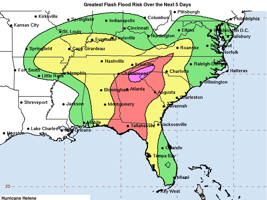
While hurricanes typically weaken quickly after landfall, Helene may remain a hurricane for 12 hours or more as it barrels north, threatening trees and power lines in areas far from the coast that may not be used to strong tropical systems. And there are concerns about flooding not just along Florida's shoreline, but far inland, from Atlanta to the Carolinas.
As of midday Wednesday, a hurricane warning is in effect for parts of Florida from the Anclote River to Mexico Beach, meaning hurricane conditions are expected in the area within 36 hours. A hurricane watch is in effect from Englewood to Anclote River, including Tampa Bay, signaling that hurricane conditions are possible within 48 hours.
Tropical storm warnings are also in effect for the Upper Florida Keys, southern Florida Peninsula and northeast coast of Florida. The NHC has also extended them westward along the Florida Gulf coast and northward along the Georgia and South Carolina coasts.
Florida races to prepare for landfall
The National Weather Service says Wednesday is the last full day for people to prepare for the storm — including making an emergency kit, reviewing an emergency plan and signing up for local weather alerts. People should also check whether they live in an evacuation zone.
More than 20 Florida counties are either under voluntary or mandatory evacuation orders as of Wednesday morning, according to the state’s Division of Emergency Management. It’s also offering assistance getting people to shelters in the Big Bend region.
Florida Gov. Ron DeSantis declared a state of emergency for 61 counties (out of 67) on Tuesday, allowing officials to make resources available in advance of the storm. President Biden also approved an emergency declaration.
DeSantis said in a tweet that Florida has 18,000 linemen — and counting — staged, as well as search and rescue and roadway clearing crews at the ready.
“As always, Florida will prepare for the worst and hope for the best,” he added.
Several institutions of higher education, including the University of Florida, Florida State University and Florida A&M University are canceling classes and closing their campuses on Thursday and, in some cases, through the weekend.
NASA and SpaceX are delaying a launch that was supposed to send crew members to the International Space Station on Thursday. Instead, they say it will happen no sooner than Saturday.
Southern states are bracing for impact, too
Current models of Helene’s path show the storm moving inland, passing through Georgia and parts of Alabama, Tennessee and Kentucky through the weekend. Even though the storm is due to make landfall in Florida, officials warn that these areas will likely see significant rainfall, winds and power outages, too.
The NHC warns that "devastating" hurricane-force winds are expected across parts of northern Florida and southern Georgia as the center of the storm travels away from the coast.
"Because of Helene’s expected fast forward speed, damaging and life-threatening wind gusts, are expected to penetrate well inland over portions of the southeastern United States, including in the higher terrain of the southern Appalachians," it says.
A tropical storm watch in effect for the South Carolina coast, north of the Savannah River.
"We don't normally issue tropical storm watches this far inland, especially here over the Appalachians area," National Hurricane Center Deputy Director Jamie Rhome said during a midday briefing. "That's unusual, you really need to be paying attention."
Potentially life-threatening flash flooding and urban flooding are expected across parts of Florida, the Southeast, the Southern Appalachians and the Tennessee Valley from Wednesday through Friday.
“This includes the risk of landslides across the southern Appalachians,” the NHC says.
The National Weather Service has already issued a rare "high risk of excessive rainfall" notice for the southern Appalachians for Thursday, warning of rain totals from 5 to 10 inches.
Tornadoes could occur Wednesday night over parts of the western Florida Peninsula and southern Alabama, it says, with the risk increasing on Thursday and expanding across Florida and into parts of Georgia and South Carolina.
Georgia Gov. Brian Kemp has declared a state of emergency, and officials there are warning of a “fast-moving” storm that could bring rainfall statewide, as well as high winds and significant power outages in certain areas.
The Georgia Emergency Management and Homeland Security Agency is telling residents to shelter in place and be ready to live without power for at least 72 hours.
Even farther north, North Carolina Gov. Roy Cooper declared a state of emergency on Wednesday afternoon, citing Helene's potential to "seriously disrupt essential utility services and systems."
Deputy national editor Russell Lewis contributed to this report.


