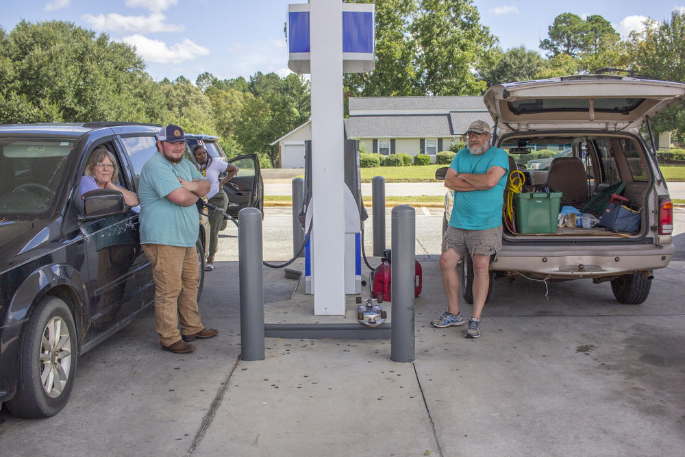
Helene is moving through Georgia and has been downgraded to a tropical storm. All of Georgia remains under warnings through Friday. This storm may have tropical storm force winds, flash flooding and tornadoes, among other hazards. Residents are advised to follow guidance for all warnings.

Further NWS weather advisory information is available for Central and North Georgia and Southwest Georgia and Coastal Georgia.

For current watches and warnings from the National Weather Service including your localized forecast, click here.

Flooding is affecting parts of the state. Here you will find an interactive flood map, information describing the different types of flooding and educational material. Here's what to do during and after a flood.

The Georgia Emergency Management and Homeland Security Agency (GEMA) has information on how to secure property and more ahead of tropical storms, read more here

For more information about the storm, follow this blog or GPB.org/Storms for updates and resources.

See below for latest updates.
___

STorm Helene moves across Georgia at 8 a.m. on Friday, Sept. 27, 2024.
Caption

Storm Helene moves across Georgia at 8 a.m. on Friday, Sept. 27, 2024.

Credit: NWS

Friday, Sept. 27 at 9 a.m.

Be water aware!

Flooding is affecting parts of the state. Here you will find an interactive flood map, information describing the different types of flooding and educational material.  Here's what the NWS says to do during and after a flood.

Here are links to resources as Georgians deal with the aftermath of Hurricane Helene:

___

Friday, Sept. 27 at 8 a.m.

Storm-related deaths are being reported in Wheeler, Laurens, Jeff Davis and Colquitt counties as Georgians deal with the remnants of Hurricane Helene as the storm rapidly makes its way north through the state. 

Tropical storm warnings and flash flood warnings remain in effect for parts of the state.

Widespread power outages, fallen trees, street flooding are primary issues. To report an outage to Georgia Power or view its statewide outage map, click here.  Findenergy.com is reporting more than 1.1 million Georgians currently with power outages from Georgia Power and local EMCs.. 

Early this morning, Gov. Brian Kemp issued an executive order authorizing an additional 1,000 Georgia National Guard troops to assist in those ongoing recovery efforts as needed in addition to the 250 heading into the field already.

Officials in Atlanta, August, Athens and other cities are asking residents stay off the roads if at all possible. 

Travelers heading to Hartsfield-Jackson International Airport are advised to check with their airline to determine if their flights are delayed or canceled. Currently, 62 flights from Atlanta have been canceled with more than 100 flights from Atlanta delayed. Passengers on Atlanta-based Delta Air Lines will have access to travel waivers to rebook flights leaving by Tuesday, Oct. 1.

____

Thursday, Sept. 26 at 6:08 p.m.

GPB's Sofi Gratas reports:

Before dark on Thursday evening, Yurshema Flanders, who runs LAMP in Valdosta, said they were making final preparations. 

“We're still actively looking for additional cots so we can accommodate, whether they're mattresses or those camping cots,” Flanders said. "Just kind of keeping everybody calm. And we're going to break out some games."

LAMP, or Lowndes Associated Ministries to People, is the only homeless shelter in Valdosta that temporarily houses men, women and children all together. Flanders said as of around 5:30 p.m. on Thursday, their emergency shelter was at capacity, though still accepting some people. Around 30 other residents at their full-time shelter were safe in place. 

Lowndes County and several others in South Georgia issued early curfews as Hurricane Helene is expected to hit the hardest overnight. Normally, LAMP would be open 24 hours. 

Flanders said they’ve received several food donations and support from the community “even without us asking.” They’ve also been working with other local shelters like those run by the United Way and Salvation Army to get unhoused people to shelter. 

“We have some other friends of the shelter that helped us go out earlier today,” she said. “We've made sure that they got to another shelter that was closer to where they were already staying.

Of top concern for Flanders is a likelihood of power outages, which would affect medication and food storage in the shelter's freezers. 

Helene is expected to hit South Georgia with hurricane-force winds around 8 p.m. Thursday. The Lowndes County Emergency Management Agency is warning residents of “significant impact” by 11 p.m. 

Across South Georgia residents in mobile homes or unsafe housing are encouraged to seek emergency shelter though no mandatory evacuations have been issued.

———

Thursday, Sept. 26 at 5 p.m.

NPR Tracking App

NPR has launched an app for local updates along the path of Hurricane Helene, click here to see.

___

Thursday, Sept. 26 at 4:30 p.m.

Flooding happening around the state before Helene arrives

___

Thursday, Sept. 26 at 3:15 p.m.

Category upgrade

According to the National Hurricane Center, Hurricane Helene was upgraded to a Category 3 hurricane with wind speeds of 120 mph.

The storm has potential to become a Category 4 hurricane.

___

Thursday, Sept. 26 at 3:05 p.m.

Important update from Macon-Bibb: Mayor declares state of local emergency

Reported by GPB's Sofi Gratas

Mayor Lester Miller declared a Local State of Emergency for Macon-Bibb County beginning Thursday, Sept. 26, 2024, in response to the forecasted impacts of Hurricane Helene.

Emergency Management Agency (EMA) Director Spencer Hawkins has activated operations under the Local Emergency Operation Plan.

“I want our community to take this seriously and take the precautions needed,” Miller said. “Please check on your neighbors and stay safe.”

Macon-Bibb County is currently under a hurricane warning and tornado watch.

To stay informed, sign up for automatic calls, texts, and emails from MBCAlert at www.maconbibb.us/mbcalert, download the MBCAlert App, and follow the Emergency Management Agency on Facebook and X.

___

Thursday, Sept. 26 at 2:30 p.m.

Sandbagging in Savannah

Reported by GPB's Benjamin Payne

In Savannah, residents discuss preparations for Hurricane Helene.

The City of Savannah is providing free sandbags to residents in the parking lot of Enmarket Arena until 8 p.m. or until weather conditions become unsafe.

John and Deborah Thomas loaded sandbags into their pickup truck this morning.

They told GPB Savannah's east side gets easily flooded.

"I wish there would be a better, more effective drainage system here in Savannah," John Thomas said.

"Savannah knew we were going to have this much rain," Deborah Thomas said. "I think we should have been more prepared — much more prepared than what we are. And the neighbors in our neighborhood, there's nothing we could do but try and deter the water. You can't stop it, but you can deter it."

John and Deborah Thomas of Savannah stand outside their pickup truck after loading it with sandbags provided by the city in the parking lot of Enmarket Arena on Thursday, Sept. 26, 2024, in anticipation of Hurricane Helene.
Caption

John and Deborah Thomas of Savannah stand outside their pickup truck after loading it with sandbags provided by the city in the parking lot of Enmarket Arena on Thursday, Sept. 26, 2024, in anticipation of Hurricane Helene.

Credit: GPB / Benjamin Bayne


Thursday, Sept. 26 at 1:30 p.m.

GEMA Update

Gov. Brian Kemp provided an update at the GEMA press conference detailing the state agencies preparing to help with the storm throughout the state.

Gov. Brian Kemp at a 1:30 p.m. GEMA press conference with updates on Hurricane Helene's impact on the state of Georgia. Screenshot
Caption

Gov. Brian Kemp at a 1:30 p.m. GEMA press conference with updates on Hurricane Helene's impact on the state of Georgia.

Credit: Screenshot

The Department of Transportation is advising the public to stay off the roads if not “necessary,” Kemp said.

“[The Georgia Department of Transportation] wanted to have me ask all our citizens: If it is not necessary for you to be on the roads during and after the storm, please try to stay home," he said. "This is a big storm; it’s going to affect our entire state."

“We feel certain we’re going to have debris and to clear roads statewide, so instead of deploying a bunch of resources to one part of the state like we normally do before a storm, we’re expecting to have to deal with debris fields in all parts of the state,” he added. “We’re going to have a lot of people that we need to get moving to get the roads clear and if there are people in our way, that’s just going to slow down our process — and it’s very dangerous as well.”

Georgia Power has about 10,000 linemen deployed and ready to go as soon as the storm slows down and wind surges pass.

On the status of the Hurricane Helene, the storm is currently a Category 2. But Kemp urged caution still.

“It doesn’t really matter what category this storm is; it’s one of the biggest that we’ve ever seen in the Atlantic from a size perspective on the width of it,” Kemp said. “We believe it can remain hurricane strength as it moves up through Macon and possibly into metro Atlanta tomorrow evening.”

Kemp said the storm will travel north throughout Georgia but will exit around midday Friday.

___

Thursday, Sept. 26 at noon

Warner Robins Sandbags

Reported by Ron Wildman

Cars lined up Thursday morning in Warner Robins where the city was offering free sandbags to help protect property from flooding as Hurricane Helene approached.

Cars lined up Warner Robins. Credit: Ron Wildman
Caption

Cars lined up Warner Robins.

Credit: Ron Wildman

Houston County Sandbags. Credit: Ron Wildman
Caption

Houston County Sandbags.

Credit: Ron Wildman

___

Thursday, Sept. 26 at 11 a.m.

NWS Update

Hurricane Helene is strengthening as rain fall hazards continue to increase in affected states. Here is the latest from the National Weather Service:


More help set to go

Reported by GPB's Grant Blankenship

Tree service workers who traveled to Macon, Ga., from Memphis, Tenn., stage in a church parking lot in Macon's Shirley Hills neighborhood, where residents have already experienced isolated power outages.

Memphis, Tennessee tree service workers in Macon, Georgia. Grant Blankenship/GPB News
Caption

Memphis, Tennessee tree service workers in Macon, Georgia.

Credit: Grant Blankenship/GPB News

___

Thursday, Sept. 26 at 10 a.m.

Important update from North Georgia

Reported by GPB's Sofi Gratas

Flood warnings were issued for many parts of Georgia early Thursday morning as Hurricane Helene rolls toward Florida.

Meanwhile the Atlanta area and some counties in North Georgia are expected to receive 10 or more inches of rain. 

Bryce Barrett with the Emergency Management Agency in White County, in the northeast corner of the state, says they’re preparing for damage similar to Hurricane Irma, which hit Georgia in 2017. 

Similar to now, the state had experienced dry conditions prior to the storm, making floods a top concern.

"So the biggest things that we're stressing to the public, especially today, is, you know, for them to have, preparedness kits," Barrett said, "To have their food and their water ready to go without power."

Barrett says residents should sign up for emergency alerts through their county systems.

White County and its neighbors are facing a 70% risk of flash flooding through Friday morning according to the National Weather Service. 

Director of Public Safety David Murphy told residents this morning to avoid driving through standing water, and stay home as much as possible. 

Barrett said the White County EMA is aware of who may need additional assistance due to medical conditions or age through a partnership with local assistance agencies. 

“We learned from Irma that, you know, White County can definitely be affected by hurricanes and tropical storms,” Barrett said. “When it comes to just our infrastructure and preparing, we're kind of … getting ready for the storm that way.”


Utility trucks

Reported by GPB's Grant Blankenship

Out of state utility trucks waiting to be deployed amidst the severe weather. Grant Blankenship/GPB News
Caption

Out of state utility trucks waiting to be deployed amidst the severe weather.

Credit: Grant Blankenship/GPB News

utility trucks from out of state were parked and waiting to be deployed in Macon, Ga.

___

Thursday, Sept. 26 at 9:45 a.m.

Atlanta Airport

Reported by GPB's Marylynn Ryan

As Georgia prepares for Hurricane Helene, dozens of flights have already been delayed or cancelled at Hartsfield-Jackson Atlanta International Airport.

FlightAware currently shows over 100 flight delays and over 100 flight cancellations so far Thursday.

On Wednesday, more than 1,100 flights were delayed at the airport. 

___

Thursday, Sept. 26 at 8:30 a.m.

Tornado Watch

The National Weather Service of Atlanta shared a post on X that a tornado watch has been issued for areas in Georgia and South Carolina until 9 p.m.

Shelters opening ahead of Hurricane Helene

Reported by GPB's Grant Blankenship

To ensure the safety of residents ahead of Hurricane Helene, GEMA/HS will open shelters. These shelters will provide a safe place for those in the storm's path to seek refuge.

Click  here to view more information about shelter locations and availability.

See the shelters on a map here.

___

Wednesday, Sept. 25 at 6 p.m.

Hurricane Helene is likely to cause flooding in some parts of Georgia through Friday, Sept. 27, 2024.

Impacts on land:

WIND: Hurricane conditions are expected within the U.S. hurricane warning area late Thursday, with tropical storm conditions beginning Thursday morning. Tropical storm conditions are expected in southern Florida later this evening and will spread northward across the rest of Florida, Georgia, and South Carolina through Thursday night. Hurricane conditions, especially in gusts, are expected in the hurricane warning area in Mexico during the next several hours. Tropical storm conditions are occurring in the warning area in Cuba, and hurricane conditions are possible for the western portion of Cuba this evening.

RAINFALL: Hurricane Helene is expected to produce total rain accumulations of 4 to 8 inches over western Cuba, the Cayman Islands and the northeast Yucatan Peninsula, with isolated totals around 12 inches. This rainfall brings a risk of considerable flooding. Over portions of the southeastern U.S. into the southern Appalachians, Helene is expected to produce total rain accumulations of 6 to 12 inches with isolated totals around 18 inches. This rainfall will likely result in catastrophic and potentially life-threatening flash and urban flooding, along with significant river flooding. Landslides are possible in steep terrain across the southern Appalachians. 

TORNADOES: A tornado or two may occur tonight over parts of the Florida Peninsula and southern Alabama. The risk of tornadoes will increase on Thursday, expanding northward across Florida into parts of Georgia and South Carolina.

Hurricane Helene is likely to cause flooding in some parts of Georgia through Friday, Sept. 27, 2024.
Caption

Hurricane Helene is likely to cause flooding in some parts of Georgia through Friday, Sept. 27, 2024.

Credit: NWS

___
 

Wednesday, Sept. 25 at 5:45 p.m.

The remaining games vs. the New York Mets scheduled for Sept. 25 and Sept. 26 have been postponed due to current and forecasted weather impacting the Atlanta area. Both games have been rescheduled as part of a traditional doubleheader on Monday, Sept. 30. The first game will begin at 1:10 p.m. ET.  Game 2 will begin approximately 40 minutes after the last out of Game 1.  Monday is a single admission doubleheader with only one ticket required for both games. 

___

Wednesday, Sept. 25 at 4:30 p.m.

Grady Hospital issued a statement notifying the public that it will remain open for operations regardless of the severe weather in the area:

"We are aware of the severe weather expected in our area due to Hurricane Helene. The safety of our patients and staff is our top priority. With that in mind, all of Grady’s clinics and neighborhood health centers will be closed starting Thursday, September 26, at Noon and remain closed on Friday, September 27. All elective and non-urgent procedures scheduled for Friday, September 27, will be rescheduled for a later date.

"Grady Hospital will remain open and operational regardless of severe weather conditions. Grady’s leadership and emergency management team will closely monitor the latest weather developments."


Wednesday, Sept. 25 at 3:30 p.m.

GEMA has shared a list of their shelters open for seeking refuge due to Hurricane Helene:

GEMA Shelter List. Provided by GEMA.
Caption

GEMA Shelter List

Credit: GEMA

In sports-related news, the Savannah Bananas rescheduled their Thursday, Sept. 25 game for Sunday, Sept. 29.

The City of Atlanta held a press conference on the storm, led by Atlanta Mayor Andre Dickens.

___

Wednesday, Sept. 25 at 2:30 p.m.

Updates and tips from Georgia Power and the Red Cross

From GPB's Orlando Montoya:

Hurricane-force winds are now possible as far north as Macon as Georgia braces for Hurricane Helene.

The National Hurricane Center's latest update has the entire state under hurricane or tropical storm warnings or a tropical storm watch.

The heaviest winds are expected Thursday night into Friday morning.

That will come after a front drops heavy rain today, making the ground wet and setting the stage for widespread power outages when the winds arrive.

John Kraft is the media spokesman for Georgia Power.

 "It's appropriate to call 911 if you see a downed power line," he said. "We also caution residents who want to get out and start cleaning up storm debris to watch for downed wires that could be tangled in trees, fallen trees, lines that could be hidden in submerged water that could still be energized."
 

John Kraft from Georgia Power talks about potential problems from Hurricane Helene.

The Red Cross is urging residents to prepare for three days without power.

Suzanne Lawler is the organization's spokesperson in Georgia.

"Charging cellphones may become hard if you lose power," she said. "So all of those phone numbers that we have in our phones and we just push a button and they just dial somebody, that may not happen in a storm. So you want to write down people's phone numbers. Any important phone numbers that you have in your phone, write them down right now and have that with your important documents."


Suzanne Lawler from the Red Cross reminds residents to keep important phone numbers handy.

For Georgia storm resources and the latest Georgia news on Helene, visit GPB.org/storms.

___

Wednesday, Sept. 25 at 2:15 p.m.

School closure updates:
 

Baldwin County School District

Banks County Schools
Banks County Schools will be closed for students and staff on Thursday, Sept. 26 and Friday, Sept. 27. All sports and extra-curricular activities will be canceled for Thursday and Friday, as well.

Cherokee County School District

Clayton County Schools
All athletic events, both indoor and outdoor, have been canceled/postponed for Wednesday and Thursday, Sept. 25-26, 2024.

Hall County Schools
The Hall County School District will conduct school from home both Thursday and Friday of this week. Twelve-month employees for the district should report to work tomorrow at their designated sites unless contacted by their supervisors. All extracurricular events for both Thursday and Friday are canceled or postponed.

Muscogee County Schools

Twiggs County Schools

Twiggs County Schools will be closed Thursday and Friday. All activities including Homecoming events will be cancelled Thursday, Sept. 26 and Friday, Sept. 27. Homecoming activities will be rescheduled and further communication will be given about the festivities at a later date.

___

Wednesday, Sept. 25 at 2:10 p.m.

Valdosta Mayor Scott Matheson Declares State of Local Emergency Due to Impending Hurricane Helene

Mayor Scott Matheson has officially declared a State of Local Emergency for the City of Valdosta in response to the imminent threat posed by Hurricane Helene. The Proclamation of Declaration was signed this morning, invoking the City of Valdosta’s Code of Ordinances, Chapter 30 - Civil Emergencies, including Article II: State of Emergency Curfew and Article III: Emergency Management.

This declaration enables the City to implement necessary emergency measures to safeguard the public and mitigate the effects of the approaching storm. Citizens are encouraged to stay vigilant, follow city and county directives, and take precautions to protect their safety.

“We are working with Lowndes County Emergency Management and closely monitoring Hurricane Helene’s path and are prepared to take swift action to protect our community,” said Mayor Matheson. “We ask all residents to remain calm, stay informed, and follow safety protocols as we prepare for the storm.”

Further updates will be provided as the situation develops. Residents are advised to follow official city and county communications for the latest information and guidance.

–––

Wednesday, Sept. 25 at 2 p.m.

An important update from the NWS about wind warnings in Southwest Georgia:

Thomas County Ga
Caption

Thomas County, Ga. has shared a wind impact graphic depicting the possibilities of wind speeds greater than 130 mph in the region.

Credit: NWS

Latest forecast track guidance for Southwest Georgia from the National Hurricane Center has Hurricane Helene over the eastern Gulf of Mexico (about 225 miles west-southwest of SRQ) early Thursday morning. This system is forecast to continue northward and make landfall in the Florida Big Bend vicinity Thursday evening.

As the storm moves northward throughout the day, the strong wind field accompanying it will expand northward as well, beginning over the Florida Peninsula Thursday morning before reaching into Georgia during the afternoon and into South Carolina by Thursday evening.

These increased winds will result in long, looping hodographs with more than enough low-level shear to support tornado formation.Tornadoes are most likely within the low-topped convection within these rainbands, so a low-probability tornado risk will begin early across the Florida Peninsula before spreading northeastward over time.

A relatively greater tornado risk is anticipated later, with best overlap between these rainbands and the strong low/mid-level flow beginning over FL during the late afternoon and moving into Georgia and South Carolina during the evening and overnight. Highest tornado potential is still anticipated across coastal GA and SC Low Country after midnight (in the early hours of Friday morning).


___

Wednesday, Sept. 25 at 1 p.m.

An important update from Atlanta Watershed Management:

Due to a strong low-pressure system that may produce heavy rainfall, high winds, and potentially localized flooding, it is vital that Atlanta residents keep a close eye on local weather advisories. Residents should take the necessary precautions if they are under a flood warning or encounter flood conditions.

  • Find safe shelter right away.
  • Do not walk, swim, or drive through flood waters. The water can be contaminated or electrically charged. Turn Around, Don’t Drown!
  • Remember, just six inches of moving water can knock you down, and one foot of moving water can sweep your vehicle away.
  • Stay off bridges over fast-moving water.


Depending on the type of flooding:

  • Evacuate if told to do so.
  • Move to higher ground or a higher floor.
  • Stay where you are.
  • Never drive around barricades. Local responders use them to safely direct traffic out of flooded areas.

For more information, please visit www.ready.gov/floods#prepare.

___


Wednesday, Sept. 25 at 12:40 p.m.

Tune into GPB.org at 5 p.m. today to watch the GEMA press conference about Hurricane Helene:

GEMA logo

__

Wednesday, Sept. 25 at 12:35 p.m.

An update from GPB's Sofi Gratas on how Hurricane Helene might affect Georgia's peanut crops:

By late Tuesday afternoon, Jeremy Kichler with the University of Georgia Extension Office in Southwest Georgia’s Colquitt County, said he had farmers coming to him with peanut crop samples. 

“To have the maturity checked on them,” Kichler said. 

If they’re mature, Kichler says farmers will likely harvest crops up until the storm hits to stem potential losses. 

“That's the big question that we have right now is when to dig, if to dig, and you know, how far off from optimum maturity they are,” Kichler said. 

Georgia peanuts are a multi-million dollar crop for the state. Cotton, a billion dollar crop, is also at risk with the storm though mostly if the white, fluffy bolls are already exposed. 

___

Wednesday, Sept. 25 at 11:30 a.m.

Helene was upgraded to a hurricane just before 11 a.m. this morning. Here is the latest from the National Weather Service:


Wednesday, Sept. 25 at 11:15 a.m.

Helene was upgraded to a hurricane just before 11 a.m. this morning. The latest forecast for Georgia shows the entire state under various watches and warnings as the hurricane moves up Florida's Gulf Coast and eventually to Georgia and parts of the southeastern U.S.

This image from the National Weather Service shows hurricane warnings in dark red, hurricane watches in bright red, tropical storm watches in pink, flood watches in green and high wind watches in gold. Visit weather.gov for your local forecast.

The entire state of Georgia is covered in storm watches and warnings. Visit Weather.gov to see your local forecast.
Caption

The entire state of Georgia is covered in storm watches and warnings. Visit Weather.gov to see your local forecast.

Credit: NWS

___

Tuesday, Sept. 24 at 3 p.m.

GEMA Director James C. Stallings at a September 24, 2024, 3 p.m. press conference briefing on Tropical Storm Helene.
Caption

GEMA Director James C. Stallings at a September 24, 2024, 3 p.m. press conference briefing on Tropical Storm Helene.

Credit: Screenshot

GEMA held a press conference to give the state of Georgia’s first official response to Tropical Storm Helene. GEMA Director James C. Stallings led the conference with a few updates on the storm and how the state is preparing to respond to the storm.

“GEMA and Homeland Security is actively monitoring Tropical Storm Helene’s forecast and working with state and local partners to ensure that resources are available when needed,” he said. “We have prepositioned response teams and equipment to quickly address emergencies as they arise.

Stallings shared that Gov. Brian Kemp has issued a state of emergency for all Georgia counties.

“That makes the state resources available to all local governments and entities within the storm’s potential impacted area,” he said.

Tropical Storm Helene is expected to intensify quickly into a major hurricane tomorrow morning and become a major hurricane at Category 3 or stronger by Thursday.

“Heavy rainfall will begin across Georgia as soon as Wednesday night into Thursday morning,” Stallings said. “Heavier rain will start to overspread the state throughout the day and on Thursday. The heaviest impacts for us will be in southern Georgia and we expect those to enter the state early with heavy rain and strong wind.”

He explained how this storm is very different than the most recent Hurricane Debby which he says was “a very slow, heavy rain event.”

“This is going to be a fast moving wind event with rain and so we anticipate a very different response,” he said.

Georgians in certain parts of the state can possibly expect high-force winds, downed trees causing power outages, flash flooding, tornadoes, and more. North and Central Georgia can expect to see major impacts as early as Friday morning to Friday afternoon.

Stallings encourages those wanting to stay up to date with information to follow official GEMA social media accounts.


Tuesday, Sept. 24 at noon

Georgia Agriculture Commissioner Tyler Harper issued a statement urging farmers and producers to prepare for the severe weather coming from Tropical Storm Helene.

“Our team at the Georgia Department of Agriculture is closely monitoring the development of Tropical Storm Helene in coordination with GEMA and other state agencies,” Agriculture Commissioner Tyler Harper said. “To Georgia farmers and producers in the potential impact zone — now is the time to prepare and make a plan to keep your family and your farm safe. As the storm approaches, we urge all Georgians in its path to remain vigilant and follow a trusted news source for updates.”


Tuesday, Sept. 24 at 11:30 a.m.

The National Hurricane Center provided an update with the latest news on what is now Tropical Storm Helene. NHC Deputy Director Jamie Rhome says the storm has acquired enough organization to be classified a tropical storm instead of being classified a Potential Tropical Cyclone No. 9.

He explained the storm will approach the Florida peninsula as a major storm on Thursday. 

"It is going to be a big storm — and by 'big' I mean not intensity; I mean size," he said. "And big storms cause big problems."

Rhome says those in states like Georgia, South Carolina and Alabama can expect more updates on the storm in subsequent updates.

In the excessive rainfall outlook, he says surrounding states, including Georgia, can expect to receive heavy rainfall and potential flooding.

"We could see a potential big rain event unfolding for you."


Monday, Sept. 23

The National Hurricane Center is issuing advisories on Potential Tropical Cyclone Nine, a disturbance located over the northwestern Caribbean Sea and headed into the Gulf of Mexico. The organization forecasts over the next seven days that the weather system has a 90% chance of becoming a tropical storm and, potentially, a hurricane.

If that happens, its name will be "Helene."

As of Monday, Sept. 23, the National Weather Service reported the system, southwest of Cuba, is moving toward the north near 6 mph (9 km/h). A northwestward motion is expected on Tuesday and Tuesday night, followed by a faster northward or north-northeastward motion on Wednesday and Thursday.

"On the forecast track, the center of the system is forecast to move across the northwestern Caribbean Sea and into the southeastern Gulf of Mexico during the next couple of days," the agency predicted. "Maximum sustained winds are near 30 mph (45 km/h) with higher gusts. Strengthening is expected during the next few days, and the system is forecast to become a hurricane on Wednesday and continue strengthening as it moves across the eastern Gulf of Mexico."

A map of the potential storm cone (see image above) predicts that the center of the cone will cross the Florida panhandle through the center of Georgia, potentially bringing heavy rains and strong winds on Thursday and Friday.

Visit the National Hurricane Center to follow the storm's path.