Section Branding
Header Content
Forecasters warn of 'unsurvivable' storm surge as Helene races toward Florida
Primary Content
As Hurricane Helene closes in on Florida’s northwest coast, forecasters are warning communities hundreds of miles away to prepare for the wrath of its flooding rains and powerful winds.
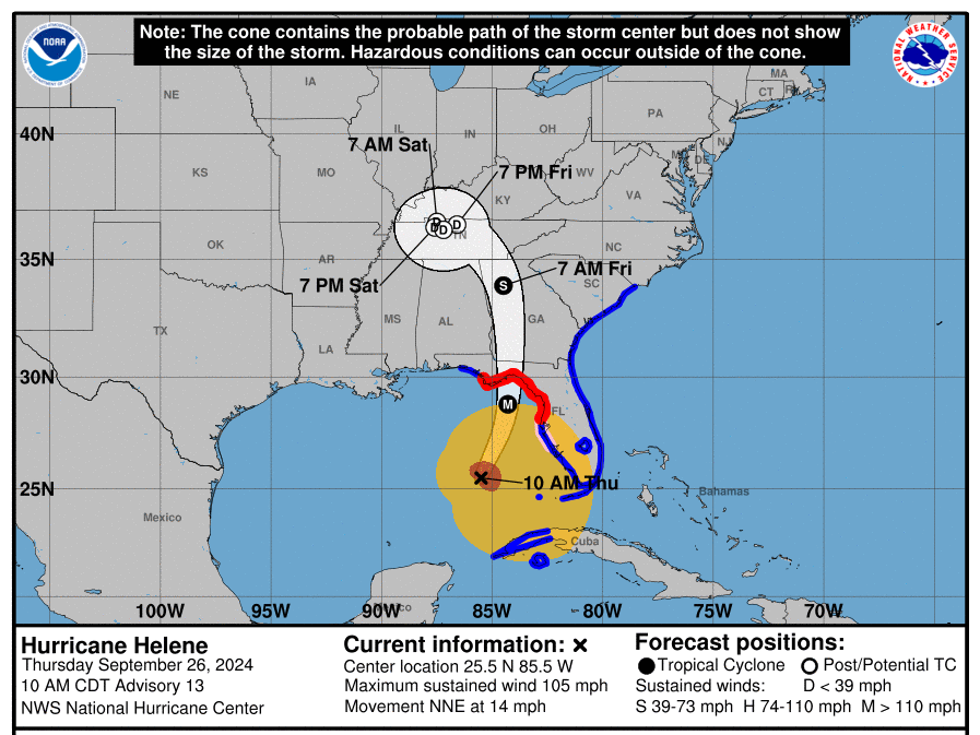
Helene is gaining strength and picking up speed as it moves across the Gulf of Mexico, and is expected to make landfall on Florida's Big Bend coast Thursday evening as a "major hurricane," the National Hurricane Center (NHC) says.
Forecasters emphasize that the storm is unusually large, with hurricane-force winds extending outward up to 60 miles from its center and tropical-storm-force winds reaching up to 345 miles away.
"In fact, comparing the system with previous hurricanes in the Gulf of Mexico over the past couple of decades, Helene is at the upper bound in terms of size," the NHC says, adding that preparations to protect life and property should be "rushed to completion."
As of 11 a.m. ET, Helene was about 255 miles southwest of Tampa with maximum sustained winds of 105 mph — maintaining its Category 2 status but intensifying quickly.
Tropical storm conditions reached the Florida Keys and portions of south Florida by late morning, with flooding reported in areas including Naples, Treasure Island, Tampa, Sarasota and St. Petersburg. Some parts of North Carolina have already seen 8 to 12 inches of rainfall associated with the storm since Wednesday morning, according to the National Weather Service (NWS).
Forecasters say Helene will continue to strengthen, with expected maximum winds at landfall of 120 mph, which would make it a Category 3 storm.
“As a result, storm surge, wind, and rainfall impacts will extend well away from the center and outside the forecast cone, particularly on the east side,” the NHC warns.
The storm is expected to move inland at a high speed, bringing strong winds and rain — and with it, the risk of flash flooding, landslides, falling trees and power outages — across the southeastern U.S., as far north as the Appalachians.
There is also a growing risk of tornadoes late Thursday into Friday, especially in northern Florida and southeast Georgia, South Carolina's Midlands and Low Country and southern North Carolina.
The storm is forecast to dump 6 to 12 inches of rain over portions of the southeast, with 20 inches possible in some areas.
In a rare news release, federal forecasters note that flooding from extreme rainfall is the deadliest direct cause of tropical cyclone fatalities in the U.S. over the past decade.
They urge residents in the storm’s path to heed evacuation orders, make a plan to protect their families and property and avoid roadways if flooding is in the forecast.
"Take this storm seriously," Deanne Criswell, the administrator of the Federal Emergency Management Agency (FEMA), told reporters on Thursday. "Please don’t underestimate what the impacts could possibly be."
Florida’s coast could see storm surge as high as 20 feet
Forecasters warn that a “catastrophic and deadly” storm surge is likely along portions of Florida's Big Bend coast, where inundation could reach as high as 20 feet.
Forecasters say that if peak surge occurs around the time of high tide, water could reach as high as 10 to 20 feet in certain areas, including Carrabelle and Apalachicola.
"The deepest water will occur along the immediate coast near and to the east of the landfall location, where the surge will be accompanied by large and dangerous waves," the NHC warns.
For context, Hurricane Ian in 2022 caused storm surges of up to 18 feet and killed roughly 150 people, most of whom died by drowning.
The NWS in Tallahassee is warning of an “unsurvivable” storm surge for Apalachee Bay that could wash away buildings, flood escape routes, damage docks and marinas and strand small craft.
St. Petersburg Mayor Kenneth Welch warned at a Thursday briefing that the area will see an "unprecedented" storm surge of 5 to 8 feet over 12 to 36 hours.
There is also a danger of a “life-threatening” storm surge along the entire west coast of the Florida Peninsula, with over 6 feet forecast from Indian Pass in the panhandle to south of Tampa.
“This is very, very serious," the NWS says.
Dozens of Florida counties are under either mandatory or voluntary evacuation orders. Several counties, including Pinellas and Citrus, have ordered evacuations of nursing and assisted living facilities.
By midday Thursday, officials in Florida began warning residents that if they had not yet evacuated, they should shelter in place as roads become increasingly dangerous.
Many public school districts and institutions of higher learning, as well as several airports, are closed for at least the day.
Florida Gov. Ron DeSantis has expanded an emergency declaration to cover nearly the entire state, 61 out of 67 counties.
Helene is “a storm stronger than what we have seen in this region, I think, in anyone’s memory,” he warned at a press briefing on Wednesday.
Florida emergency officials urged residents to evacuate if they live in areas facing possible storm surges or surrounded by big trees that could fall on their houses.
They are reminding people to remove loose items from outdoor areas, move any electric vehicles to higher ground and never run a generator indoors. They also urged Floridians to expect extended power outages, which utility Florida Power & Light Co. says it’s pre-positioned to address when it’s safe to do so.
Criswell said FEMA has deployed more than 1,110 personnel, including eight search and rescue teams, to Florida since Monday, and staged food, water and generators. The Army Corps of Engineers has also readied power restoration teams and debris removal specialists.
"We are postured for whatever response might be needed," she added.
Once the storm leaves Florida, it’s set to weave a destructive path through Georgia, the Carolinas and the Appalachians.
“We’re just the opening act,” DeSantis said.
States as far north as Virginia are bracing for heavy wind and rain
After Helene makes landfall, it’s expected to turn northwestward and slow down over the Tennessee Valley on Friday and Saturday.
“Helene's fast forward speed will allow strong, damaging winds, especially in gusts, to penetrate well inland across the southeastern United States, including over the higher terrain of the southern Appalachians,” the NHC says, warning of life-threatening winds over parts of northern Florida and southern Georgia late Thursday.
It is forecasting total rainfall amounts of up to 18 inches in the Appalachian region, with major flood risks in the urban areas around Tallahassee, metro Atlanta and western North Carolina, including Asheville.
Over 12 million people live within the area deemed high risk of excessive rainfall through Thursday evening, according to the NWS, which warned against walking or driving onto flooded roads.
Forecasters also warn of “catastrophic and life-threatening” flash and urban flooding across the southern Appalachians through Friday, with river flooding also likely.
"Numerous significant landslides are expected in steep terrain across the southern Appalachians," they say.
The governors of Georgia, South Carolina, North Carolina and Virginia have declared states of emergency as the storm bears down.
Areas 100 miles north of the Florida-Georgia line can expect hurricane conditions, per The Associated Press. More than half of Georgia’s public school districts and several universities canceled classes.
In the metro Atlanta area — which is under a tropical storm warning — major events have been canceled or delayed, including campaign events by Republican vice presidential nominee JD Vance and the final two games of a high-stakes series between the New York Mets and Atlanta Braves.
The National Weather Service in Atlanta warns that damaging wind gusts — and a high risk of downed trees and power lines — are likely through Friday, as is an increased tornado risk.
“Please have multiple ways to receive warnings and make sure your phone is not on silent overnight!” it tweeted.
Here are more tips for staying safe before, during and after a hurricane from the National Weather Service, the American Red Cross and NPR.


