Section Branding
Header Content
Dreaming of a white Christmas? There's hope, depending on where you live
Primary Content
If you're hoping to wake up on Christmas morning to white fluffy stuff on the ground, there's a chance you might get your wish.
Christmas magic won't bring snow to the majority of the country, but some parts might just get lucky, according to Scott Kleebauer, a meteorologist with the National Weather Service Weather Prediction Center.
"If you are one of those people that does get a chance to enjoy a white Christmas, definitely feel very lucky and very blessed to be able to enjoy something like that, as it looks like a lot of people this year will not be able to," Kleebauer tells NPR.
While hopes for a white Christmas are on many minds each year, experts say the chances of experiencing one may diminish in the future, in part because of shifts in weather patterns driven by global warming.
Here is what the weather is likely to look like on Christmas Day across the country and how a changing climate may impact Christmases to come.
Will you have a white Christmas?
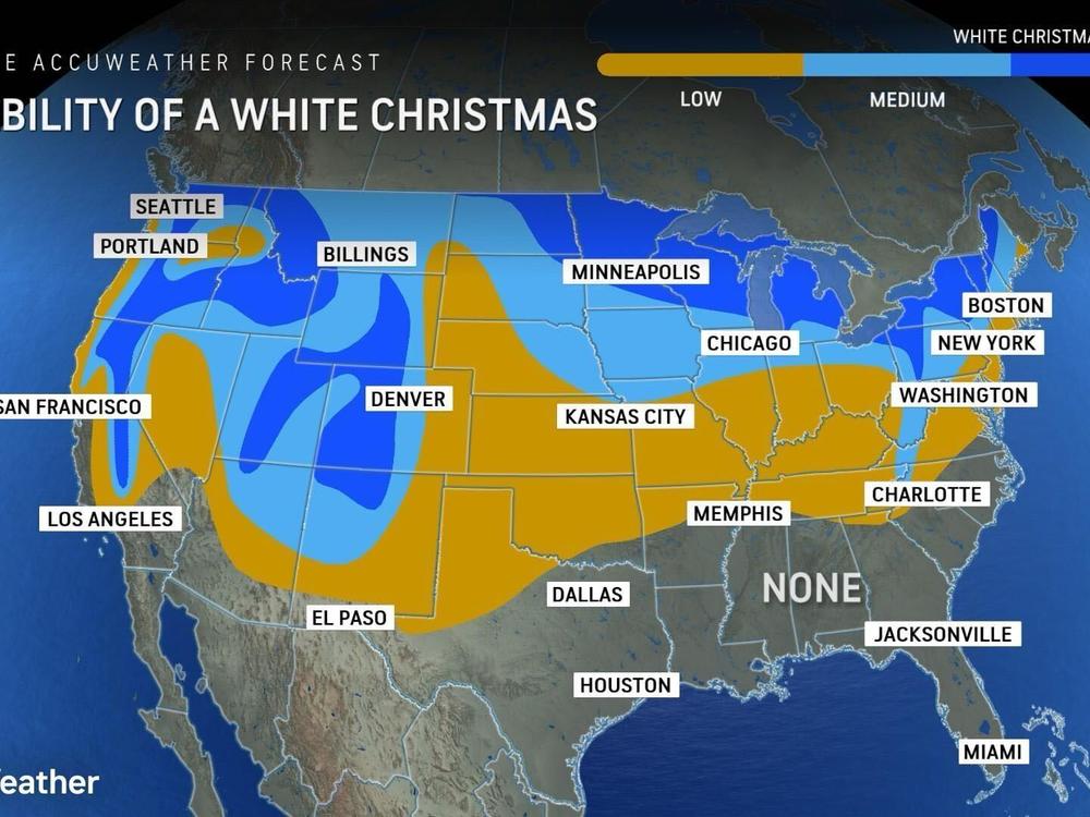
The areas that have the highest chances for a white Christmas — when there is at least 1 inch of snow on the ground on Christmas morning — will be out west in the Rockies, around the Great Lakes and in higher terrain in northern New England, Kleebauer says. Parts of the Appalachian Mountains across the high country of West Virginia, western Maryland and into western Pennsylvania also have a chance for snow.
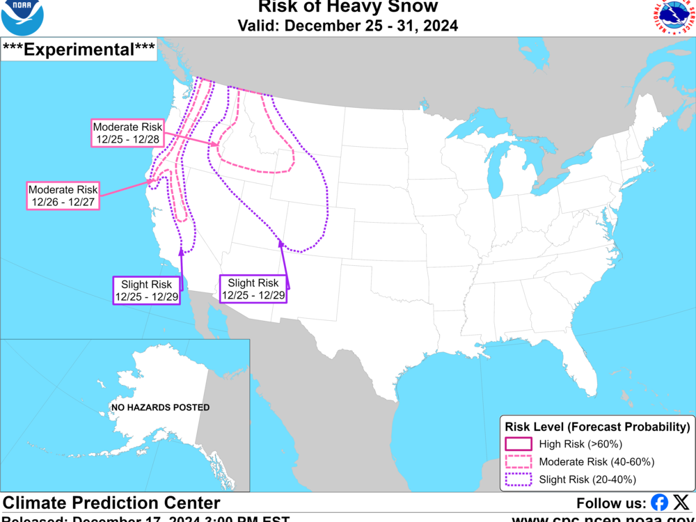
There's also a high chance of "heavy precipitation and high elevation snow" in northern California and parts of the Pacific Northwest on Christmas Eve that will start again on Dec. 26, according to the NOAA Climate Prediction Center, or CPC.
"A storm system in the Pacific Northwest could bring mountain snow as Santa is making his rounds, and the CPC features a moderate potential for Heavy Snow Hazards in the northern Rockies, especially in the Cascade Mountains and the Bitterroot Range of Idaho," Erica Grow Cei, meteorologist and spokesperson for the National Weather Service, tells NPR.
Most of the country is also expected to have temperatures that are "milder than average" on Christmas Eve and Christmas Day, according to NOAA. Temperatures are expected to be near normal to slightly above normal across portions of the Plains and into the southeastern portion of the country. States including Texas and Florida are forecast to see temperatures in the 70s.
So far, 2024 has been the warmest year on record globally and is likely to beat the record set just last year, according to NOAA. The year is also on track to be one of the warmest two years ever recorded in the contiguous U.S.
Warmer temperatures could impact future white Christmases
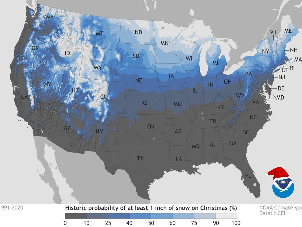
Historically, parts of the northern U.S., the Rockies and the Sierra Nevada Mountains have had the highest likelihood of experiencing a white Christmas, according to Kleebauer and a map by NOAA's National Centers for Environmental Information.
The last time the majority of America woke up to a white Christmas was nearly 15 years ago, Kleebauer says. On Dec. 19, 2009, a large snowstorm blanketed parts of the Northeast starting in Virginia and dumped more than 12 inches of snow on Boston, with snow lingering through Christmas Day. Snow also fell in other parts of the country during that time, resulting in "large snow coverage across the United States, even into those areas that don't see white Christmases too often," he says. Texas was one of those areas.
But because of warmer temperatures driven by climate change, the coldest temperatures are becoming less frequent in parts of the country.
When looking at changes in monthly and seasonal temperatures — along with the number of snowy days — "it is clear that winter is the fastest warming season across 74% of the United States, with the northeastern United States and Upper Midwest," says Elizabeth Burakowski, a research assistant professor at the University of New Hampshire.
Since the 1970s, the U.S. has seen rapidly warming temperatures, according to the federal government's most recent National Climate Assessment, released by the U.S. Global Change Research Program.
"As the world's climate has shifted toward warmer conditions, the frequency and intensity of extreme cold events have declined over much of the US, while the frequency, intensity, and duration of extreme heat have increased," the assessment says. "Across all regions of the US, people are experiencing warming temperatures and longer-lasting heatwaves. Over much of the country, nighttime temperatures and winter temperatures have warmed more rapidly than daytime and summer temperatures."
As temperatures rise, more precipitation is expected to fall as rain instead of snow, particularly in areas in the western part of the U.S., the assessment also found. These temperatures will also lead to "earlier snowmelt, altered rates of snowmelt and evaporation directly from the snow, and longer snow-free periods," the assessment says.
So far this winter, snowfall across parts of the U.S., including areas of the Prairie Pothole region including North and South Dakota, southern portions of Minnesota and Wisconsin, has been below normal, according to Shawn Carter, Winter Hydrology Desk lead at NOAA's Weather Prediction Center. Government data shows that snowfall in the Sierra Nevadas and the Cascades are well above normal, while the Rockies are seeing a mix of normal to slightly below normal levels, Carter also says.
White Christmases are a sentimental favorite, but they are also a powerful example of how the world's climate is changing.
"Seeing changes in the chances of a white Christmas is one of so many ways we may experience climate change," Burakowski says. "When we come together as a community to address climate [change], we're preserving so much more than snow on Christmas day."


