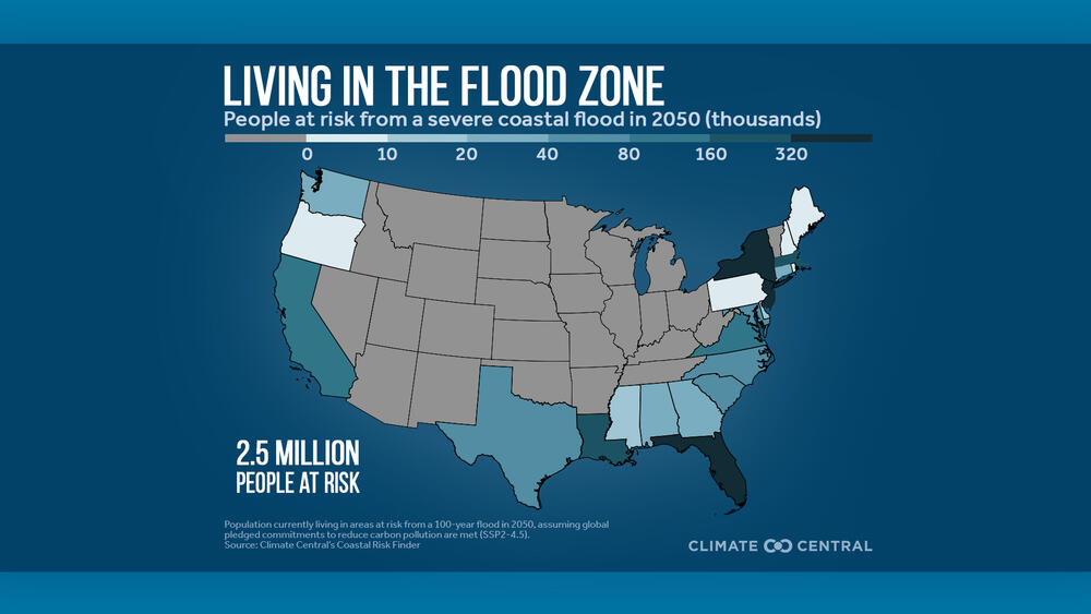
Caption
A map from the science nonprofit Climate Central shows the state-by-state risk for severe flood vulnerability by population along the East, Gulf, and West Coasts.
Credit: Climate Central
LISTEN: Georgia's severe flood zone spans an area larger than Atlanta, New York City, and Los Angeles combined, according to new research. GPB's Benjamin Payne reports.

A map from the science nonprofit Climate Central shows the state-by-state risk for severe flood vulnerability by population along the East, Gulf, and West Coasts.
A new scientific analysis released Wednesday has found that just over 1,000 square miles of land in Coastal Georgia lies at risk of a severe flood by 2050, as sea levels continue to rise amid global warming.
Researchers at the nonprofit group Climate Central studied the threat of "100-year" floods — defined as those traditionally having a 1% chance of occurring in any given year — in an effort to quantify the threat posed by coastal flooding across the contiguous U.S.
Their data show that the flood zone in Georgia comprises roughly 27% of the state's six counties that touch the Atlantic coast, from Savannah's Chatham County down south to Camden County along the Florida border.
The 1,011-square-mile zone — home to about 24,000 people — encompasses an area slightly larger than the combined size of Atlanta, New York City, and Los Angeles.
An interactive map showing the flood zone can be accessed on Climate Central's Coastal Risk Finder tool, where users can enter their state, city, or county for a more precise view, as well as search by congressional and state legislative districts.
The findings noted that rising sea levels heighten tides and storm surges, effectively pushing a flood's potential reach further inland.
In Georgia, that means the severe flood zone includes some communities over 10 miles away from the Atlantic coastline, including Midway and Riceboro in Liberty County and Woodbine in Camden County, among others.
Older Georgians are disproportionately vulnerable to severe flooding: according to the analysis, people 65 and older make up 27% of residents living in the severe flood zone, nearly double their statewide 14% share of the population.
Georgia's severe flood zone square mileage is the sixth-highest in the coastal U.S., behind Louisiana (9,164 sq. mi.), Florida (4,210), Texas (1,885), North Carolina (1,756), and South Carolina (1,414).
Climate Central's analysis assumes that the U.S. follows through on earlier commitments it has made to reduce fossil fuel emissions — pledges that now stand on shaky ground under the Trump administration: in March, the EPA announced that it would begin rolling back 31 environmental rules and regulations.