Section Branding
Header Content
Tropical Storm Eta Could Become A Hurricane, Dousing Florida With A Foot Of Rain
Primary Content
Updated 1:34 a.m. ET Monday
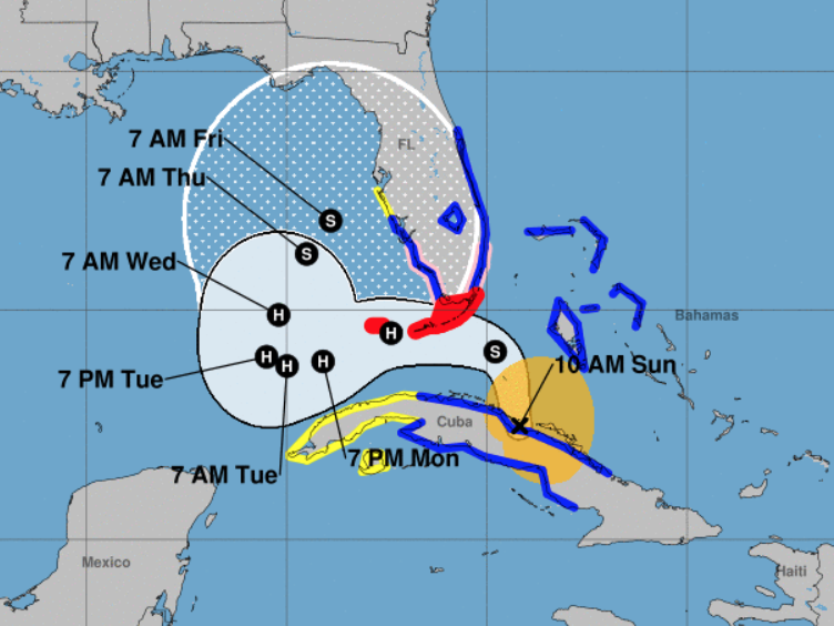
Tropical Storm Eta made landfall late Sunday in the Florida Keys. The southern part of the state faces a potential one-two punch from Eta, which could strengthen into a hurricane and drop up to a foot of rain before retreating to the Gulf of Mexico to gather strength for round two.
The National Hurricane Center says Eta had maximum sustained winds of 65 mph on Sunday night and was centered about 30 miles east-northeast of Marathon, Fla., and 70 miles east-northeast of Key West. It was moving west-northwest at 14 mph.
After making landfall in Cuba early Sunday, Florida now faces storm surges of up to four feet. The National Hurricane Center has issued a hurricane warning, and a storm surge warning for much of the Florida Keys.
Eta would be the first named storm of the season to make landfall in Florida, according to the Weather Channel. Gov. Ron DeSantis declared a state of emergency Saturday in eight southern counties ahead of the storm: Broward, Collier, Hendry, Lee, Martin, Miami-Dade, Monroe and Palm Beach. School is canceled Monday in Miami-Dade and Monroe counties, both in person and online.
Regardless of when exactly Eta becomes a hurricane, forecasters expect heavy rainfall to continue to drench portions of Cuba, Jamaica, the Bahamas,and as far north as central Florida.
Perhaps befitting a year known for bruising surprises, after Eta's first pass at Florida, there may be a second. The storm is expected to regroup in the Gulf of Mexico, where it could shift northward and head back toward the state's western coast.
"You're going to be dealing with this all week," said NHC Director Ken Graham. "It's going to take a while to get this thing out of here."
Copyright 2020 NPR. To see more, visit https://www.npr.org.

