Section Branding
Header Content
Georgia Flooding: Cleanup, Damage Assessment Begins
Primary Content
Latest flood watches/warnings from the National Weather Service
Check flood gauges in your community from the Southeast River Forecast Center
UPDATE (1/1/16 7:52 a.m.): Staff from the Georgia Emergency Management Agency are helping local governments assess flood damage. Flood warnings remain in effect along many of the state's rivers. Forecasters say there is still a risk of rising water in low-lying areas.
In Southwest Georgia, Bainbridge residents have put out thousands of sandbags, as the Flint River is forecast to crest later this weekend.
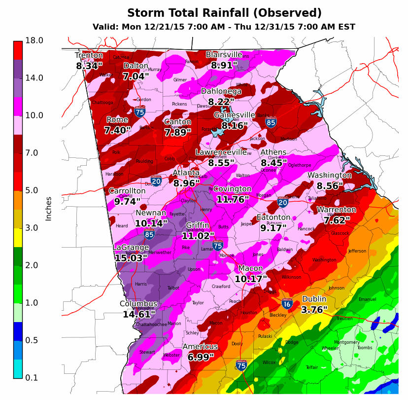
Last month was one of the warmest and wettest Decembers on record. The National Weather Service says Atlanta, Athens, Columbus, and Macon set new records for average temperatures.
Many parts of the state also saw record rainfall, from about 11 and a half inches in Macon to nearly 16 inches in Columbus
UPDATE (12/31/15 8:02 a.m.):Gov. Nathan Deal has declared a state of emergency in five more Georgia counties hard-hit by flooding in recent days.
Deal's issued the order Wednesday night for Gordon, Macon, Towns, Troup and Wilkes counties. It also extends an earlier state of emergency in Fannin, Gilmer and Pickens counties.
Much of the state saw another one to two inches of rain Wednesday. A shopping center flooded in Covington, roads in Wilkes County are washed out, the riverwalk in downtown Columbus is closed., and Albany officials are getting ready for the Flint River to rise again.
A flash flood watch is in effect until Friday afternoon across the state's mid-section, including Augusta, Americus, LaGrange, Macon and Columbus.
UPDATE (12/30/15 12:12 p.m.): The water at Lake Lanier is at levels not seen since the 1980s. Near non-stop rain has brought the lake to 1074.64 feet, as of Wednesday morning. Army Corps of Engineers spokeswoman Lisa Parker says they want to bring the lake down by releasing more water through Buford Dam.
But first, the rain needs to stop. "We don't want to increase any potential flooding downstream at West Point, so it would be a controlled release as well as monitoring future rain events as they come into the basin," she says. Parker says the water release will likely start Friday. It will take 30 days for the lake's level to drop by five feet.
Water releases are underway at other dams in Georgia, including Allatoona and West Point.
Meanwhile officials in Oconee County say a small, earthen dam may fail and are asking residents of a nearby subdivision to evacuate.
UPDATE (12/29/15 7:49 p.m.): The National Weather Service has extended the flash flood watch until 7 p.m. Friday. The watch area now includes Columbus, Macon, and Americus. Forecasters expect another 1 to 3 inches of rain, with higher totals in Central and South Georgia.
UPDATE (12/28/15 2:34 p.m.): Authorities in Georgia have confirmed two deaths due to flooding.
Gordon County Chief Deputy Robert Paris said they've recovered the body of a man whose car was swept away when water overtook his car. Paris said the car was located late Sunday, but it wasn't safe for divers to reach it in the swift-moving waters until Monday.
The man's name wasn't released. Paris said he was from Chattooga County.
Paris said the second body was recovered Monday at Self Lake, and authorities were investigating how that person died,
UPDATE (12/28/15 10:10 a.m.):
A flood watch is in effect from 1 p.m. Monday until 7 p.m. Thursday. The watch area covers much of the state--from the North Carolina and Tennessee borders, and south along a line from La Grange to Athens. Forecasters at the National Weather Service expect an additional two to four inches of rain in the watch area. Rainfall totals will be heaviest in the Northeast, including Gainesville and Dahlonega.
Authorities in Gordon County are searching for two missing people. According to the Calhoun Times, troopers believe a car is submerged in fast-moving water in the Reeves Station community. Divers from the Georgia State Patrol are trying to reach the vehicle. Rescuers are also looking for another man in the Sonoraville community.
Here are other developments from around the state, as of Monday morning.
-In Middle Georgia, James Conner, head of the Macon County Emergency Management Agency, says the Flint River crested at 22 feet there Sunday and is on the ebb. Conner says the emergency shelter opened for residents last night went unused and that the Red Cross is packing up those resources and heading to Laurens, two watersheds east on the Oconee River. More than a dozen homes in Macon County have flooded.
-Officials in Albany are keeping an eye on the Flint River, which is forecast to crest at 31.5 feet Wednesday evening.
UPDATE:
Officials in Macon County have declared a state of emergency, due to the threat of flooding. County workers, fire and rescue personnel are adding sandbag reinforcements to the Montezuma Levy, as the Flint River is forecast to reach flood stage by Monday.
EARLIER:
A forecaster says north and central Georgia will be dealing with flooding throughout the weekend and the beginning of next week.
National Weather Service hydrologist Kent Frantz said Saturday that counties in those regions could have an extra two to four inches of rain next week. Frantz says there was an isolated 8 to 12 inches of rain from Fort Benning to LaGrange.
Gov. Nathan Deal declared a state of emergency Thursday in three north Georgia counties including Fannin, Gilmer and Pickens through Jan. 10.
Frantz says metro Atlanta hasn't experienced much flood problems, but soils are still very wet from the constant rain the past few days. Frantz says a flood watch might be put on because of additional 2 to 4 inches of rain.
EVACUATIONS IN SOUTHWEST GEORGIA
The Weather Service says there is still a risk of flooding along the Flint River and Kinchafoonee Creek in Southwest Georgia. WALB reports crews are rescuing families who live along Creekside Place in Lee County.
The Albany Fire Department is warning of one street along the Flint River to be prepared to evacuate, as the river continues to rise and is forecast to crest at 34-36 feet on Wednesday.
Bottom Content
