Section Branding
Header Content
Rain and flooding across Georgia: What you need to know
Hero Image
Primary Content
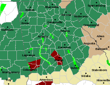
As a storm front moved across Georgia in the overnight hours Sunday and throughout the day Monday, heavy rainfall caused flooding on roadways and rivers swelled. The National Weather Service is urging residents to be aware of possible flooding conditions and to exercise caution when driving.
People who live near rivers are most likely to be affected by this storm as waters rise and then recede Tuesday when sunshine moves into the northern half of the state. In Savannah, thunderstorms Monday evening will give way to partly cloudy skies after midnight. There is a potential for severe thunderstorms.
Vulnerable areas include Central Chattahoochee County in west central Georgia, southeastern Harris County in west central Georgia, northwestern Marion County in west central Georgia, Muscogee County in west central Georgia and southwestern Talbot County in west central Georgia, where a flash flood warning remains in effect until 12:30 p.m.
Other areas with potential for flooding include Columbus, Talbotton, Waverly Hall, Geneva, Upatoi, North Fort Moore, Bibb City, Fort Moore, Midland, Ellerslie, Flat Rock, Box Springs, Eelbeck/West Fort Moore, Cataula, Baughville, Kenwood, Vista Terrace, Juniper, Edgewood and Columbus Metropolitan Airport.
The National Weather Service has an interactive map to help predict river flooding. View the map here to see if a river near you may be affected.The Georgia Department of Transportation provides information about street closures, incidents and road construction, some of which my be weather related. If you live in one of the counties affected by the flooding, view the GDOT map here before you head out during heavy rain or on roads near low-lying areas.
NWS reminds drivers: "Turn around, don't drown when encountering flooded roads. Most flood deaths occur in vehicles."
Secondary Content

Bottom Content
